
Sittingbourne topographic map
Click on the map to display elevation.
About this map
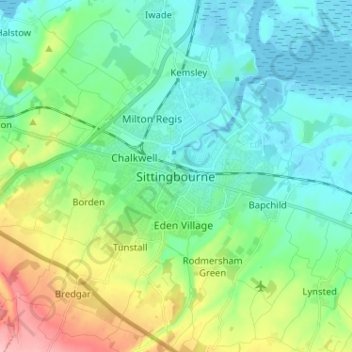
Name: Sittingbourne topographic map, elevation, terrain.
Average elevation: 37 m
Minimum elevation: -2 m
Maximum elevation: 139 m
Other topographic maps
Click on a map to view its topography, its elevation and its terrain.
Faversham Creek
United Kingdom > England > Kent > Borough of Swale > Faversham > Oare
Average elevation: 8 m
Faversham Creek
United Kingdom > England > Kent > Borough of Swale > Faversham > Oare
Average elevation: 11 m
Oare Creek
United Kingdom > England > Kent > Borough of Swale > Faversham > Oare
Average elevation: 6 m