Geolocate

Upchurch topographic map

Click on the map to display elevation.

About this map

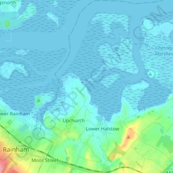
Name: Upchurch topographic map, elevation, terrain.

Location: Upchurch, Borough of Swale, Kent, England, United Kingdom (51.35296 0.62326 51.42927 0.69736)

Average elevation: 10 m

Minimum elevation: -3 m

Maximum elevation: 87 m

Other topographic maps

Click on a map to view its topography, its elevation and its terrain.

Sittingbourne

United Kingdom > England > Kent > Borough of Swale

Average elevation: 37 m

Newhouse

United Kingdom > England > Kent > Borough of Swale

Average elevation: 9 m

The Swale

United Kingdom > England > Kent > Borough of Swale

Average elevation: 12 m

Norton

United Kingdom > England > Kent > Borough of Swale

Average elevation: 35 m

Seed

United Kingdom > England > Kent > Borough of Swale > Doddington

Average elevation: 101 m

Wallend

United Kingdom > England > Kent > Borough of Swale > Minster

Average elevation: 7 m

Grove End

United Kingdom > England > Kent > Borough of Swale > Tunstall

Average elevation: 65 m

Howt Green

United Kingdom > England > Kent > Borough of Swale > Bobbing

Average elevation: 19 m

Keycol Hill

United Kingdom > England > Kent > Borough of Swale

Average elevation: 40 m

Halfway

United Kingdom > England > Kent > Borough of Swale

Average elevation: 6 m

Graveney

United Kingdom > England > Kent > Borough of Swale

Average elevation: 8 m

Oare Creek

United Kingdom > England > Kent > Borough of Swale > Faversham > Oare

Average elevation: 6 m

Hook's Hole

United Kingdom > England > Kent > Borough of Swale > Borden

Average elevation: 45 m

Uplees

United Kingdom > England > Kent > Borough of Swale

Average elevation: 5 m

Key Street

United Kingdom > England > Kent > Borough of Swale > Borden

Average elevation: 40 m

Minster

United Kingdom > England > Kent > Borough of Swale

Average elevation: 9 m

Gore

United Kingdom > England > Kent > Borough of Swale > Upchurch

Average elevation: 19 m

Bay View

United Kingdom > England > Kent > Borough of Swale > Warden

Average elevation: 12 m

Sittingbourne

United Kingdom > England > Kent > Borough of Swale

Average elevation: 37 m

Trouts

United Kingdom > England > Kent > Borough of Swale > Eastchurch

Average elevation: 24 m

Norton Ash

United Kingdom > England > Kent > Borough of Swale > Norton

Average elevation: 30 m

Lewson Street

United Kingdom > England > Kent > Borough of Swale > Norton

Average elevation: 36 m

Dargate

United Kingdom > England > Kent > Borough of Swale

Average elevation: 40 m

Oversland

United Kingdom > England > Kent > Borough of Swale

Average elevation: 73 m

Ham Green

United Kingdom > England > Kent > Borough of Swale > Upchurch

Average elevation: 4 m

Gear up for your next adventure:

🩹Compact First Aid Kit - Pre-packed essentials for common trail injuries
🥤Collapsible Travel Cup - Saves space and weight in your mess kit
🥾Approach Boots - Comfortable boots for hiking and climbing approaches
🛁Quick-Dry Microfiber Towel - Space-saving towel that dries rapidly on the move
🥾Mountaineering Boots - Supportive boots for climbing and high-altitude hiking

As an Amazon Associate, this site earns from qualifying purchases at no extra cost to you.