Geolocate

Doddington topographic map

Click on the map to display elevation.

About this map

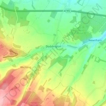
Name: Doddington topographic map, elevation, terrain.

Location: Doddington, Borough of Swale, Kent, England, United Kingdom (51.25636 0.74961 51.30195 0.81360)

Average elevation: 103 m

Minimum elevation: 48 m

Maximum elevation: 182 m

Other topographic maps

Click on a map to view its topography, its elevation and its terrain.

Seed

United Kingdom > England > Kent > Borough of Swale > Doddington

Average elevation: 101 m

Gear up for your next adventure:

🔥Emergency Fire Starter - Reliable ignition source for all weather conditions
🥾Mountain Hiking Boots - High-traction boots for rocky terrain
💧Collapsible Water Bottle - Space-saving water bottle for outdoor activities
🥾Waterproof Hiking Boots - Essential footwear for rugged terrain and wet Canadian trails
🗺️Topographic Maps - Detailed maps to explore trails, mountains, and wilderness areas

As an Amazon Associate, this site earns from qualifying purchases at no extra cost to you.