
Viola topographic map
Click on the map to display elevation.
About this map
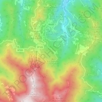
Name: Viola topographic map, elevation, terrain.
Location: Viola, Cuneo, Piedmont, Italy (44.24482 7.93995 44.30514 8.00356)
Average elevation: 1,051 m
Minimum elevation: 567 m
Maximum elevation: 1,750 m
Other topographic maps
Click on a map to view its topography, its elevation and its terrain.
Colle Fauniera
Italy > Piedmont > Cuneo > Demonte
The Colle Fauniera is a mountain pass in the Cottian Alps, Piedmont, northern Italy, located at 2,480+ m elevation.
Average elevation: 2,315 m
F.ne Scaglione
Italy > Piedmont > Cuneo > Santo Stefano Belbo > F.ne Scaglione
Average elevation: 330 m