Geolocate

Monte Brancetta topographic map

Click on the map to display elevation.

About this map

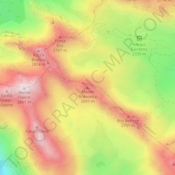
Name: Monte Brancetta topographic map, elevation, terrain.

Location: Monte Brancetta, Argentera, Cuneo, Piedmont, Italy (44.40159 7.00101 44.40169 7.00111)

Average elevation: 2,467 m

Minimum elevation: 2,004 m

Maximum elevation: 2,834 m

Gear up for your next adventure:

🕶️Polarized Sunglasses - Reduces glare from snow and water at high elevations
🥾Hiking Gaiters - Protect legs and shoes from mud, snow, and debris
🥽Outdoor Goggles - Protective eyewear for outdoor activities
🛌Insulated Sleeping Pad - Critical thermal barrier between you and the cold ground
🧤Thermal Hiking Gloves - Grip-enhanced gloves for cold-weather altitude trekking

As an Amazon Associate, this site earns from qualifying purchases at no extra cost to you.