Geolocate

Colle Fauniera topographic map

Click on the map to display elevation.

Colle Fauniera

The Colle Fauniera is a mountain pass in the Cottian Alps, Piedmont, northern Italy, located at 2,480+ m elevation.

Wikipedia (CC-BY-SA 3.0)

About this map

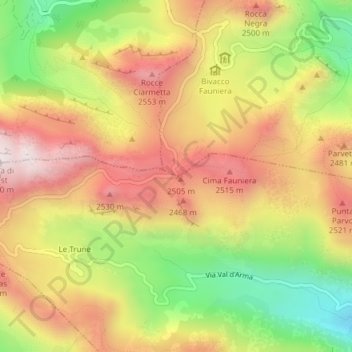
Name: Colle Fauniera topographic map, elevation, terrain.

Location: Colle Fauniera, Demonte, Cuneo, Piedmont, Italy (44.38560 7.12176 44.38570 7.12186)

Average elevation: 2,315 m

Minimum elevation: 1,958 m

Maximum elevation: 2,619 m

Gear up for your next adventure:

🕯️Camping Lantern - Illuminates your entire campsite with high-efficiency LEDs
🥾Light Trekking Boots - Supportive boots for multi-day treks
🥾Waterproof Hiking Shoes - Durable shoes for wet and rugged trails
🚲MTB Frame Bag - Carry tools and maps directly on your bicycle frame
🦶Anti-Blister Balm - Prevents friction and hotspots during long ascents

As an Amazon Associate, this site earns from qualifying purchases at no extra cost to you.