Orellana topographic map
Interactive map
Click on the map to display elevation.
About this map
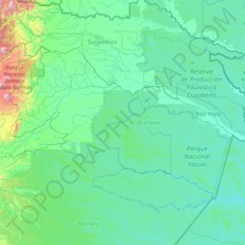
Name: Orellana topographic map, elevation, terrain.
Location: Orellana, Ecuador (-1.56425 -77.62810 -0.03784 -75.19250)
Average elevation: 350 m
Minimum elevation: 149 m
Maximum elevation: 3,637 m
Other topographic maps
Click on a map to view its topography, its elevation and its terrain.
Quito
Ecuador > Pichincha > Quito Canton
Quito's elevation of 2,850 m (9,350 ft) makes it either the highest or the second highest capital city in the world. This varied standing is because Bolivia is a country with multiple capitals; if La Paz is considered the Bolivian national capital, it tops the list of highest capitals, but if Sucre is…
Average elevation: 2,930 m
Cuenca
Cuenca, officially Santa Ana de los Ríos de Cuenca, is an Ecuadorian city, head of the canton of the same name and capital of the province of Azuay, as well as its largest and most populated city. It is crossed by the Tomebamba, Tarqui, Yanuncay and Machángara rivers, in the south-central inter-Andean region…
Average elevation: 2,789 m
Alausí
Alausi is located at an average altitude of 2,340 meters (7,677 feet) above sea level. The lowest level in the canton is 1,225 meters (4,019 feet) above sea level, in the Huigra parish and the highest is 3,340 meters (10,958 feet) above sea level in Achupallas.
Average elevation: 3,276 m
Tungurahua
Generally though, Tungurahua experiences temperatures between 14 and 17 degree Celsius in the day-time, with cooler nights. At higher altitudes, conditions are much colder. Despite the area being near the Equator, mountains such as Carihuayrazo and Chimborazo are covered in snow for much of the year.
Average elevation: 3,118 m
Loja
Loja is located in a high Andean valley at an elevation of 7,300 feet (2,225 m). It had a population of 448,966 inhabitants at the 2010 census. It is recognized as being a friendly and pleasant city. This was demonstrated when Loja, both the provincial capital and one of the oldest cities in Ecuador, won a…
Average elevation: 1,227 m
Marchena Island
Ecuador > Galápagos > Cantón Santa Cruz
The island's name, Marchena Island (Spanish: Isla Marchena), comes from the Spanish monk, Frey Antonio de Marchena. It has an area of 130 km2 and a maximum altitude of 343 meters. The island is not set up for visitors, although the surrounding water is used by aquatic divers on organised tours.
Average elevation: 50 m
Parroquia Puerto Baquerizo Moreno
Ecuador > Galápagos > Cantón San Cristóbal > Parroquia Puerto Baquerizo Moreno
Puerto Baquerizo Moreno is the capital and administrative centre of Ecuador's Galápagos Province. It is located on the southwestern coast of San Cristóbal, and the town is also nicknamed Cristóbal by the local people, after the island. Its average elevation is 6 metres (20 ft). The central part of the town,…
Average elevation: 35 m
Vilcabamba
Although the Vilcabambans did not enjoy greater longevity than the rest of the world, researchers noted that the Vilcabamban lifestyle, which included hard work in a high altitude combined with a low-calorie, low-animal-fat diet, did seem to keep the villagers healthy and vigorous in their old age.
Average elevation: 2,203 m
Galapagos Islands
The islands are found at the coordinates 1°40'N–1°36'S, 89°16'–92°01'W. Straddling the equator, islands in the chain are located in both the northern and southern hemispheres, with Volcán Wolf and Volcán Ecuador on Isla Isabela being directly on the equator. Española Island, the southernmost islet…
Average elevation: 17 m
San Francisco de la tola grande
Ecuador > Pichincha > Tumbaco > San Francisco de la tola grande
Average elevation: 2,505 m