Geolocate

Calderón topographic map

Click on the map to display elevation.

About this map

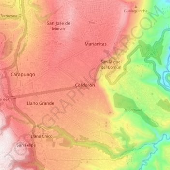
Name: Calderón topographic map, elevation, terrain.

Location: Calderón, Calderon, Quito Canton, Pichincha, 170201, Ecuador (-0.14337 -78.46376 -0.06337 -78.38376)

Average elevation: 2,542 m

Minimum elevation: 1,960 m

Maximum elevation: 2,925 m

Other topographic maps

Click on a map to view its topography, its elevation and its terrain.

Puembo

Ecuador > Pichincha > Quito Canton

Average elevation: 2,427 m

San Antonio

Ecuador > Pichincha > Quito Canton

Average elevation: 2,389 m

Calderon

Ecuador > Pichincha > Quito Canton

Average elevation: 2,466 m

Gear up for your next adventure:

🧢Hiking Hat - Sun-protective and breathable hats for long treks
🧢Sun Protection Cap - Breathable cap to protect from sun exposure
🔨Vehicle Emergency Tool - Safety tool for remote road trips to trailheads
🛏️Camping Sleeping Mat - Comfortable mats for sleeping outdoors
🥾Mountain Hiking Shoes - Shoes with superior grip for mountainous terrain

As an Amazon Associate, this site earns from qualifying purchases at no extra cost to you.