Geolocate

Playas topographic map

Click on the map to display elevation.

About this map

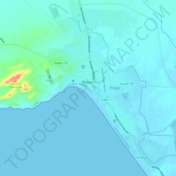
Name: Playas topographic map, elevation, terrain.

Location: Playas, General Villamil Playas, Playas, Guayas, Ecuador (-2.66773 -80.40532 -2.60770 -80.36366)

Average elevation: 9 m

Minimum elevation: 0 m

Maximum elevation: 96 m

Gear up for your next adventure:

🦯Trekking Poles - Reduced impact on joints for steep topographic climbs
🧭GPS Handheld Device - Reliable GPS navigation for outdoor adventures
🪑Insulated Seat Pad - Protect your seat from cold rocks and wet logs
🛶Kayak Dry Bag - Waterproof storage for kayaking adventures
🧭Orienteering Kit - Tools for map reading and navigation in the wild

As an Amazon Associate, this site earns from qualifying purchases at no extra cost to you.