
Lago Vista topographic map
Click on the map to display elevation.
Lago Vista
According to the United States Census Bureau, the city has a total area of 15.52 sq mi (40.2 km2) of which 14.6 sq mi (38 km2) is land and 0.6 sq mi (1.6 km2) (3.95%) is water. The peninsular city sits adjacent to, and partially within, the Balcones Canyonlands. Lago Vista has rugged terrain with elevations ranging from 774 ft (236 m) above sea level at the lake shore to 1220 ft (372 m) above sea level near Rusty Allen Airport. The area is characterized by steep limestone hills and canyons, some of the highest in Travis County.
About this map
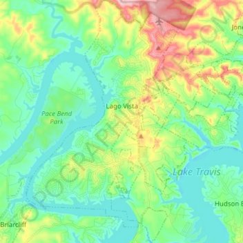
Name: Lago Vista topographic map, elevation, terrain.
Location: Lago Vista, Travis County, Texas, United States (30.39919 -98.03744 30.50717 -97.95484)
Average elevation: 251 m
Minimum elevation: 196 m
Maximum elevation: 388 m
Other topographic maps
Click on a map to view its topography, its elevation and its terrain.
Roy G. Guerrero Colorado River Metro Park
United States > Texas > Travis County > Austin
Average elevation: 141 m
Austin
United States > Texas > Travis County > Austin
The elevation of Austin varies from 425 feet (130 m) to approximately 1,000 feet (305 m) above sea level. Due to the fact it straddles the Balcones Fault, much of the eastern part of the city is flat, with heavy clay and loam soils, whereas the western part and western suburbs consist of rolling hills on the…
Average elevation: 203 m
Pflugerville
United States > Texas > Travis County > Pflugerville > Pflugerville
Average elevation: 219 m