Geolocate

Pflugerville topographic map

Click on the map to display elevation.

About this map

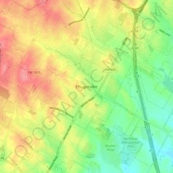
Name: Pflugerville topographic map, elevation, terrain.

Location: Pflugerville, Travis County, Texas, 78691, United States (30.39937 -97.66000 30.47937 -97.58000)

Average elevation: 219 m

Minimum elevation: 178 m

Maximum elevation: 263 m

Gear up for your next adventure:

🧥Fleece Jacket - Warm and lightweight jacket for layering
💧Collapsible Water Bottle - Space-saving water bottle for outdoor activities
🥾All-Terrain Hiking Boots - Versatile boots for varied hiking conditions
🥾Durable Hiking Shoes - Long-lasting shoes for frequent hiking
🐕Hiking Dog Pack - Let your canine companion carry their own water and food

As an Amazon Associate, this site earns from qualifying purchases at no extra cost to you.