
Mount Lucas topographic map
Click on the map to display elevation.
About this map
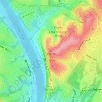
Name: Mount Lucas topographic map, elevation, terrain.
Average elevation: 196 m
Minimum elevation: 150 m
Maximum elevation: 263 m
Other topographic maps
Click on a map to view its topography, its elevation and its terrain.
Circle C Ranch Metropolitan Park on Slaughter Creek
United States > Texas > Travis County > Austin
Average elevation: 259 m
Roy G. Guerrero Colorado River Metro Park
United States > Texas > Travis County > Austin
Average elevation: 141 m
Shoal Beach at Town Lake Metropolitan Park
United States > Texas > Travis County > Austin
Average elevation: 152 m
Walter E. Long Metropolitan Park
United States > Texas > Travis County > Austin
Average elevation: 174 m