Geolocate

Point Venture topographic map

Click on the map to display elevation.

About this map

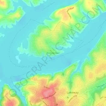
Name: Point Venture topographic map, elevation, terrain.

Location: Point Venture, Travis County, Texas, United States (30.35937 -98.01612 30.39937 -97.97612)

Average elevation: 227 m

Minimum elevation: 199 m

Maximum elevation: 288 m

Gear up for your next adventure:

❄️Traction Ice Cleats - Slip-on spikes for icy trails and winter hiking
🧢Sun Hat - Wide-brim hat for sun protection
Lightweight Camping Tent - Portable shelter optimized for Canadian backcountry camping
Lightweight Backpacking Tent - Compact tent for efficient hiking trips
🔥Camping Stove - Portable stoves to cook outdoors with ease

As an Amazon Associate, this site earns from qualifying purchases at no extra cost to you.