
Lastres topographic map
Click on the map to display elevation.
About this map
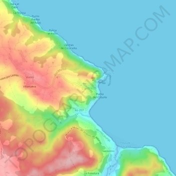
Name: Lastres topographic map, elevation, terrain.
Location: Lastres, Colunga, Asturias, 33330, España (43.49419 -5.29126 43.53419 -5.25126)
Average elevation: 56 m
Minimum elevation: -2 m
Maximum elevation: 178 m
Other topographic maps
Click on a map to view its topography, its elevation and its terrain.
Oviedo
La altitud del concejo varía entre los 55 m s. n. m. en el último tramo del río Nalón en el municipio, poco antes de su confluencia con el río Nora, y los 714 m s. n. m. que alcanza el pico Escobín, en el macizo de La Grandota, situado en el límite con Langreo. La ciudad está protegida de los…
Average elevation: 284 m
Gijón
El clima de Gijón, determinado por la presencia del mar y la baja altitud del concejo, es un clima oceánico, con abundantes precipitaciones desde el otoño hasta los primeros días de la primavera, y un tiempo más estable y cálido en verano. Según los datos ofrecidos por la Agencia Estatal de…
Average elevation: 128 m
Mieres
En invierno Mieres es una ciudad extraordinariamente fría si tenemos en cuenta su latitud, altitud y distancia de la línea de costa. La media anual de días de nieve es insignificante. Esta nieve es permanente en la cumbre de las montañas que rodean Mieres los meses más fríos del año y muy rara vez…
Average elevation: 497 m
Muros de Nalón
El conjunto del paisaje con su ría del Nalón, su gran cantidad de playas y las suaves ondulaciones de su rasa litoral le proporcionan una indudable belleza. La altitud es la más baja de los concejos con Gozón, que apenas alcanza los 130 metros. Su principal eje fluvial es el río Nalón, hay otros…
Average elevation: 61 m
Cangas de Onís
Su cota máxima de altitud la encontramos en la Torre de Santa María o Peña Santa de Enol con 2478 metros de altitud sobre el nivel del mar.
Average elevation: 591 m
Villaviciosa
El concejo se caracteriza por tener unas amplias extensiones de rasas, estando alterada la superficie de igual modo por colinas, valles, alturas, hondonadas, y cordales dirigidos casi en línea recta desde los extremos al centro, con alturas poco pronunciadas y con poca pendiente. El monte de Cualmayor en el…
Average elevation: 183 m
San Martín del Rey Aurelio
El municipio se estructura en torno a una serie de valles y cordales cuyas aguas vierten al río Nalón, que atraviesa el concejo por su parte central con una orientación Sureste-Noroeste. La zona alta del concejo se encuentra en el Paisaje protegido de las Cuencas Mineras de Asturias. La altitud media que…
Average elevation: 506 m
Somiedo
La topografía es una de la más accidentadas de todo el Principado de Asturias, teniendo alturas importantes, sucediéndose frecuentemente a lo largo de la superficie, las elevaciones y las depresiones. Las sierras arrancan de la cordillera Cantábrica en dirección sur-norte. De esta sierra, destacan los…
Average elevation: 1,299 m
Siero
Topográficamente hablando, el concejo de Siero está enmarcado en la suave depresión prelitoral asturiana, flanqueado por suaves montañas con mayor elevación en su parte más oriental, quedando encuadrada la parte centroccidental en una enorme llanura que va desde las proximidades de la capital hasta…
Average elevation: 316 m
Degaña
La villa de Degaña, capital del concejo, se encuentra situada a 852m s. n. m. por lo que se trata de la capital de concejo situada a mayor altitud de Asturias, mientras que Cerredo que es la mayor población se encuentra situado a 1 030msnm por lo que es uno de los pueblos localizados a mayor altitud de la…
Average elevation: 1,275 m
El Franco
Su relieve contiene una rasa litoral de mayor altitud que los concejos próximos, de ahí que sus cursos fluviales el Porcía y el Mazo, estén completamente encajados. La zona meridional es la más elevada, destacando al sureste la sierra de Penouta. El río Porcía hace de límite con Tapia de Casariego,…
Average elevation: 236 m
Navia
Desde el punto de vista geológico, el suelo de Navia, debido a la zona irrigada por el río, corresponde a un periodo de evolución de la tierra llamado silúrico. El diminuto río fue labrándose su cauce, y encajándose en él a medida que se retiraban las aguas oceánicas por acumulación de enormes…
Average elevation: 113 m
Cangas del Narcea
El pico más alto es el Cuetu d'Arbas, con 2007 metros de altitud, situado en el puerto de Leitariegos. Otro pico de interés es El Cabril, con 1925 metros de altitud, muy seguido por Caniechas (1924 metros).
Average elevation: 990 m
Cudillero
Su relieve se divide en tres partes. La primera es la rasa litoral que se eleva unos 100 metros sobre el nivel del mar con unos acantilados a veces rotos por numerosas playas o ensenadas, destacando en su geografía costera el Cabo Vidio (Cabu Vidíu en asturiano). En una segunda parte los valles interiores de…
Average elevation: 166 m
Grado
El concejo de Grado posee grandes diferencias en cuanto a la geografía física. Su parte norte se encuentra en la franja litoral asturiana, dominada por extensos valles y montañas de poca altitud. Mientas que la parte sur se encuentra inmersa en plena Cordillera Cantábrica, donde llega a alcanzar altitudes…
Average elevation: 554 m
Proaza
El área montañosa en el que se adentra el concejo está formado por una serie de cordales muy desarrollados y perpendiculares a la cordillera cantábrica, abriéndose camino entre ellos el río Trubia que dibuja hermosas vegas en su trayecto. Se origina de este modo una orografía con grandes diferencias en…
Average elevation: 815 m
Noreña
El concejo presenta un relieve muy poco significativo debido a que no existen grandes accidentes geográficos en la zona. Solo cabe destacar dos colinas que se encuentran en Noreña y sobre las que reside la mayor parte de la población. Una de ellas es El Rebollín, que presenta cierto desnivel y acoge a la…
Average elevation: 255 m
Llanera
El relieve está formado por parte de la llanura que se extiende al norte de Oviedo y, aunque su terreno es predominantemente llano, tiene pequeñas elevaciones entre los que destacamos: Santo Firme (439 metros), Pico del Águila (472 metros), Peña Menende (480 metros) y el pico Gorfolí de (582 metros), que…
Average elevation: 197 m
Nava
Es un concejo de suave relieve que se encuentra entre montañas, siendo sus principales alturas el Peñamayor (1150 metros) o La Triguera (1293 metros). Las cadenas montañosas más importantes son la sierra de Ques al este, haciendo de límite con Piloña, y la sierra de Peñamayor al oeste, haciendo de…
Average elevation: 437 m
Colunga
Su relieve está marcado en diferentes zonas, al suroeste está la zona Protegida del Paisaje del Sueve con alturas que no superan los 1000 metros de altitud exceptuando El Picu Pienzu de 1.159 metros, Al norte hay una especie de meseta de entre 100 y 200 metros.
Average elevation: 204 m
Pravia
Desde el punto de vista orográfico, no se puede destacar el terreno Praviano como montañoso, ya que en él son mayoría las pequeñas y medianas montañas. En el norte tenemos las sierras de Sangreña y las Autedas, al sur la sierra de Sandamías, al oeste las de Ablanedo y la Castañal y al este la sierra…
Average elevation: 212 m
Tineo
Tineo (en asturiano Tinéu) es un concejo de la comunidad autónoma del Principado de Asturias, en el norte de España; también es una parroquia y una villa de dicho concejo. El concejo de sitúa en el occidente de Asturias; está dividido en 44 parroquias que comprenden un total de 340 núcleos de…
Average elevation: 655 m
Ribadesella
El concejo riosellano posee algunas montañas considerables, algo infrecuente tan cerca del mar. La cumbre más alta pertenece a la Sierra de Escapa y es el monte Mofrechu, de 897 metros, que está en el límite con Cangas de Onís, al sureste. Otras montañas notables son la Peña Pagadín (419 metros), y La…
Average elevation: 153 m
Castrillón
Se sitúa en la rasa costera central del Principado. Su zona septentrional la conforman diversas playas y acantilados sin altitudes destacables, aglutinando la mayor parte de la población. El interior está formado por vegas y colinas, hasta encontrar al sur del municipio la sierra de Pulide.
Average elevation: 110 m
Piloña
El suelo piloñés es montañoso con pequeños valles penetrantes y estrechos, y varias montañas con mucha pendiente pero altitudes no muy pronunciadas. La mayor parte del terreno está sumida en una depresión de edad terciaria en dirección este-oeste y recorrida por el río Piloña. Gracias a los estudios…
Average elevation: 471 m
Morcín
El Aramo, en sus más altos picos, hace de muralla limitando el concejo por el suroeste con los concejos vecinos en el pico Gamonal, de una altitud de 1712 m s. n. m.. El Aramo es un lugar frecuentado por montañeros y escaladores que han llamado a Peñerudes, por su privilegiada situación para punto de…
Average elevation: 562 m
Boal
La principal elevación del terreno se encuentra lindando ya con los municipios de Illano y Castropol: es el pico de La Bobia, de 1.201 m sobre el nivel del mar. Merecen mención también La Cristaleira (1.036 m) en la zona sur del concejo, Pena Queimada (921 m) en la zona noroccidental, Penouta (899 m) en la…
Average elevation: 510 m
Teverga
Teverga es un concejo eminentemente montañoso y con fuertes pendientes, sobre las que se abren tres valles muy profundos (Valdesampedro, Valdesantibanes y Valdecárzana) en los cuales se asienta la mayor parte de la población. Rodeando estos valles, están las elevaciones más importantes, destacando en su…
Average elevation: 1,112 m
Sobrescobio
Desde el punto de vista geológico Sobrescobio se encuentra en la llamada Región de Mantos que está formada por escamas, que son unas unidades morfológicas donde se concentran las áreas de mayor altitud y están compuestas por materiales tales como calizas y cuarcitas. En el límite de estas escamas se…
Average elevation: 833 m
Las Regueras
El relieve no presenta unos accidentes destacados, constituido por montes, colinas y picos de poca altitud. Las mayores alturas se dan por el tercio occidental, con la presencia de dos alineaciones paralelas, la sierra del Cogollo por una parte, y las de Burafán, Pedroso y del Peral por la otra. En todas…
Average elevation: 239 m
Santa Eulalia de Oscos
Su suelo es mayoritariamente cambriano y silúrico, con materiales de la era paleozoica, entre los que sobresale la pizarra, deformados por la orogenia herciana que dan forma al relieve actual, con una orientación norte-sur de sus montañas entre las que sus ríos originan unos estrechos y ajustados valles.…
Average elevation: 707 m
Ibias
El relieve configura dos zonas topográficamente diferentes, aunque con rasgos similares. Al sur, se localizan las alturas y pendientes más abruptas, el resto del territorio se caracteriza por formas más suaves y culminaciones aplanadas. Esto marca un concejo con fuertes contrastes ya que va desde los 200…
Average elevation: 914 m
San Martín de Oscos
Orográficamente hablando, podemos diferenciar dos zonas en el concejo. La septentrional, presenta una topografía mucho más complicada, con la presencia de grandes pendientes, siendo los cordales de San Isidro y del Eirelo sus alturas más destacadas. La otra zona corresponde a la zona meridional, y…
Average elevation: 680 m
Allande
El territorio de Allande es extremadamente montañoso y accidentado, con una altitud media elevada, siendo utilizadas en su día casi todas las laderas para un aprovechamiento agrícola. Queda dividido en dos partes por la alineación de dirección NNE-SSO de las sierras de Leirosa, Los Lagos y Valcárcel, que…
Average elevation: 725 m
Belmonte de Miranda
Las cimas más importantes se alcanzan en la sierra de la Manteca y su pico de mayor altitud es el Horru, que se eleva a 1527 m. Otros picos de esta misma sierra son: La Chana de 1388 m, Los Calostros del Pousadoiro entre 1428 y 1474 m, por el norte esta sierra se comunica con el macizo de peña Aguda, cuyo…
Average elevation: 683 m
Yernes y Tameza
Es un concejo eminentemente dominado por la altitud y las grandes pendientes, estando más del 90 % del territorio entre los 400 y los 1200 metros, teniendo unas pendientes en más de la mitad del territorio del concejo, de entre un 21% y un 60% de inclinación.
Average elevation: 782 m
Cabranes
Municipio pequeño de orografía poco accidentada, ya que sus altitudes máximas no superan los 600 metros. Sus cotas más altas son: Incós de 578 metros y el Montaliñu de 546 metros. Cabranes, tiene una docena de riachuelos que discurren dentro del concejo, y destacan por su longitud los ríos: Sales y el Viña.
Average elevation: 298 m
Onís
Onís nos muestra una superficie diferenciada de norte a sur, siendo mucho más ancha su parte norteña. Se distinguen claramente unas zonas geográficas delimitadas por la depresión que ocupa el río Güeña: al norte, las laderas meridionales de las sierras prelitorales que anteceden al Cuera, con la cota…
Average elevation: 786 m
Peñamellera Alta
Es una comarca muy bien definida por los accidentes geográficos, que sirven de límite con otras tierras. Así, limita con Llanes a través de la sierra de Cuera, hoy espacio protegido, siendo su altura máxima de 1.315 msnm en el Pico Turbina. Con la provincia cántabra actúa de límite los Picos de Europa,…
Average elevation: 661 m
Ribera de Arriba
Su topografía está condicionada por la presencia del río Nalón en el concejo, que sigue una orientación este-oeste formando un gran valle. De sus accidentes montañosos, hay que decir que el concejo se encuentra rodeado por varios montes aunque no de mucha elevación. En la parte norteña del territorio…
Average elevation: 329 m
Santo Adriano
Respecto a su topografía hay que decir que es un concejo muy accidentado, afectado por las estribaciones de las sierras del Aramo y del Oral, que atraviesan el concejo en todas las direcciones mostrándonos una superficie desigual con fuertes desniveles y elevadas sierras calizas. Entre dichos desniveles se…
Average elevation: 496 m
Sariego
La capital del concejo de Sariego es la localidad de Vega, que se enmarca dentro de la parroquia de Santiago. Se encuentra a una altitud de 260 metros y está localizada en un amplio valle delimitado al norte por la sierra de la Llomba. Su territorio fue dependiente del monasterio de las pelayas Oviedo…
Average elevation: 360 m
Taramundi
Su topografía está conformada por montañas quebradas y escabrosas, mezcladas con diversos valles orientados en todas las direcciones y formados por los cuantiosos arroyos y riachuelos que bañan el municipio de Taramundi. El concejo representa a una figura casi ovalada delimitada por un conjunto de sierras…
Average elevation: 429 m
Illas
Ubicado en la zona central de Asturias, en la comarca de Avilés, cuenta con una superficie de 25,51km2, pequeña dentro de los concejos asturianos. La topografía del concejo es muy accidentada con fuertes desniveles y pocas tierras llanas, predominando los montes de poca altura cubiertos de arbolado. Su…
Average elevation: 277 m
Río Cares
El Cares nace en Posada de Valdeón (León), en la Cordillera Cantábrica, a 1600 m de altitud en la confluencia de varios arroyos. Desemboca en el río Deva a la altura de Vega de Llés. El Deva desemboca en el mar Cantábrico formando la ría de Tina Mayor, que constituye la frontera natural entre Asturias y…
Average elevation: 1,155 m
Pesoz
Su topografía es abrupta, pero menos escabrosa que la del contorno geográfico, con alturas inferiores a los 800 metros, siendo de mención los Cordales de Leares y San Isidro, así como la loma de Sequeiros, al norte y noroeste. La loma de Pesoz recorre el término municipal de norte a sur, limitando las…
Average elevation: 463 m
San Tirso de Abres
Respecto a su topografía, San Tirso podemos decir que se asienta sobre un valle relacionado al curso medio del río Eo que atraviesa el concejo en dirección oeste-este. No presenta grandes altitudes ni grandes pendientes, presentando las mayores alturas por el sur, concretamente en el cordal de Arredondas,…
Average elevation: 262 m
Tapia de Casariego
El relieve tiene altitudes bastantes suaves y con pocas pendientes, observándose dos zonas bastantes diferenciadas separadas por la carretera que va de Figueras a Lagar. En la parte sur de esta vía encontramos el cordal de Acevedo y los montes de Candaosa, con alturas de poca importancia entre las que…
Average elevation: 147 m
Villayón
En cuanto a la topografía del concejo, podemos afirmar que es montañoso, aflorando también diversos valles en varias direcciones conformados por los afluentes y subafluentes del Navia. Las altitudes más importantes son las siguientes: por el norte y el nordeste, tenemos las sierras de Arbón, Brañuas y…
Average elevation: 530 m
Lena
Su relieve es muy accidentado, al encontrarse en plena Cordillera Cantábrica. Por el oeste se alzan el cordal de las Segadas (hace de límite con Riosa) y el cordal de Lena (hace de límite con Quirós). El suroeste del territorio es el que cuenta con las montañas más elevadas, en el límite con San…
Average elevation: 1,108 m
Valdés
Valdés se encuadra dentro de la morfología estructural del occidente asturiano, es decir, está compuesto por grandes unidades montañosas y valles dirigidos preferentemente en dirección norte-sur. Con esto se pueden distinguir tres unidades geomorfológicas claramente diferenciadas. La costa litoral, la…
Average elevation: 332 m
Langreo
Sus montañas son de una altitud media que dificultan la comunicación con la otra cuenca del Caudal y con las de los concejos vecinos. En el extremo sur es donde se concentran las mayores altitudes que andan alrededor de los 1000 m: Destacan el Alto de San Justo de 1011 m, el pico Cogollín de 1005 m y el…
Average elevation: 453 m
Salas
En cuanto a su orografía hay que destacar que Salas presenta una orografía de media montaña y bastante homogénea, comprendiendo más del 80 % del terreno a una altitud de entre 200 y 800 metros. La villa de Salas se encuentra a una altitud de 239 metros sobre el nivel del mar. Las principales montañas son…
Average elevation: 431 m
Riosa
Su situación en la agreste montaña central asturiana en la cuenca del río Caudal ha determinado las características de este concejo a lo largo de toda su historia desde el Neolítico (6000 - 3000 a. C.). La presencia humana está atestiguada en las primeras etapas de la Edad de los Metales(Cobre, Bronce y…
Average elevation: 879 m
Laviana
La mitad occidental del territorio de Laviana forma parte de la cuenca hullera del Nalón. El relieve se compone principalmente de los valles y cordilleras formados por la erosión fluvial sobre materiales carboníferos. En la parte oriental encontramos un sustrato calizo que corresponde a las zonas de mayor…
Average elevation: 674 m
Villar de Sapos
La aldea de Villar de Sapos se sitúa a 560 metros de altitud, en la margen izquierda del río Arganza, en la ladera sur de la sierra La Pila. Se encuentra a 18 km de Pola de Allande y tiene una población de 7 habitantes (INE 2011). Su pequeña iglesia parroquial, dedicada a Santiago, tiene en su interior un…
Average elevation: 630 m
Sorribas
Las edificaciones que conforman el lugar de Sorribas se asientan en el tercio superior de la ladera noroccidental de la cuenca del arroyo Tarallongo y en el collado divisorio de esta vaguada con la del río Vega. Se orientan al sudeste, a una altitud que oscila entre los 450 y los 530 m s. n. m.
Average elevation: 368 m
Villalmarzo
La aldea se sitúa a una altitud de 200 m y dista 7,5 km de la villa de La Caridad, capital del concejo.
Average elevation: 186 m
Lago Enol
España > Asturias > Cangas de Onís
Se encuentra situado a unos 1070 m de altitud, en el macizo occidental o del Cornión (Picos de Europa), teniendo un calado máximo de unos 25 m, con un máximo de longitud de 750 m y una anchura de unos 400 m.
Average elevation: 1,081 m