
Pumar topographic map
Click on the map to display elevation.
About this map
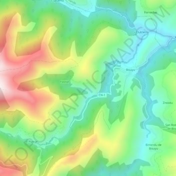
Name: Pumar topographic map, elevation, terrain.
Location: Pumar, Allande, Asturias, España (43.17057 -6.67318 43.19538 -6.62061)
Average elevation: 709 m
Minimum elevation: 451 m
Maximum elevation: 1,168 m
Other topographic maps
Click on a map to view its topography, its elevation and its terrain.
Villar de Sapos
La aldea de Villar de Sapos se sitúa a 560 metros de altitud, en la margen izquierda del río Arganza, en la ladera sur de la sierra La Pila. Se encuentra a 18 km de Pola de Allande y tiene una población de 7 habitantes (INE 2011). Su pequeña iglesia parroquial, dedicada a Santiago, tiene en su interior un…
Average elevation: 630 m