Geolocate

Villaviciosa topographic map

Click on the map to display elevation.

About this map

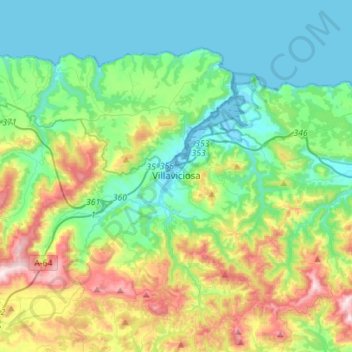
Name: Villaviciosa topographic map, elevation, terrain.

Location: Villaviciosa, Asturias, Spain (43.40690 -5.59038 43.55488 -5.31108)

Average elevation: 183 m

Minimum elevation: -6 m

Maximum elevation: 658 m

Other topographic maps

Click on a map to view its topography, its elevation and its terrain.

La Pimpana

Spain > Asturias > Quirós

Average elevation: 1,683 m

Gear up for your next adventure:

🧢Hiking Hat - Sun-protective and breathable hats for long treks
🥾Light Trekking Boots - Supportive boots for multi-day treks
🥾Lightweight Hiking Shoes - Comfortable shoes for day hikes
Camping Coffee Maker - Brew fresh coffee anywhere on the topographic map
Lightweight Backpacking Tent - Compact tent for efficient hiking trips

As an Amazon Associate, this site earns from qualifying purchases at no extra cost to you.