
Make a donation
Gear up for your next adventure:
As an Amazon Associate, this site earns from qualifying purchases at no extra cost to you.
Valdés topographic map
Click on the map to display elevation.
Make a donation
Gear up for your next adventure:
As an Amazon Associate, this site earns from qualifying purchases at no extra cost to you.
About this map
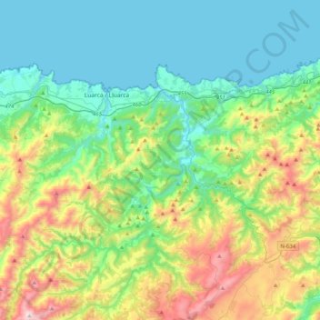
Name: Valdés topographic map, elevation, terrain.
Location: Valdés, Asturias, Spain (43.39825 -6.65755 43.57115 -6.25919)
Average elevation: 331 m
Minimum elevation: 0 m
Maximum elevation: 1,241 m
Make a donation
Gear up for your next adventure:
As an Amazon Associate, this site earns from qualifying purchases at no extra cost to you.
Other topographic maps
Click on a map to view its topography, its elevation and its terrain.
Make a donation
Gear up for your next adventure:
As an Amazon Associate, this site earns from qualifying purchases at no extra cost to you.
Make a donation
Gear up for your next adventure:
As an Amazon Associate, this site earns from qualifying purchases at no extra cost to you.
Bulnes de Arriba (El Castillo)
Spain > Asturias > Cabrales > Bulnes de Arriba (El Castillo)
Average elevation: 1,138 m
Make a donation
Gear up for your next adventure:
As an Amazon Associate, this site earns from qualifying purchases at no extra cost to you.
Arriondas / Les Arriondes
Spain > Asturias > Parres > Arriondas / Les Arriondes
Average elevation: 187 m
Make a donation
Gear up for your next adventure:
As an Amazon Associate, this site earns from qualifying purchases at no extra cost to you.