Geolocate

Proaza topographic map

Click on the map to display elevation.

About this map

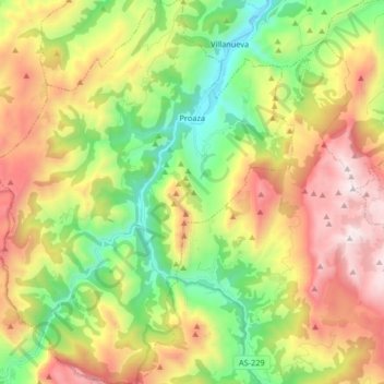
Name: Proaza topographic map, elevation, terrain.

Location: Proaza, Asturias, Spain (43.16754 -6.10464 43.28757 -5.97335)

Average elevation: 815 m

Minimum elevation: 156 m

Maximum elevation: 1,698 m

Other topographic maps

Click on a map to view its topography, its elevation and its terrain.

Don Fernandu

Spain > Asturias > Proaza

Average elevation: 584 m

Gear up for your next adventure:

🥾Waterproof Hiking Boots - Boots keeping your feet dry in wet conditions
Camping Groundsheet - Protect your tent from moisture and dirt
🧥Waterproof Jacket - Lightweight rain jackets for hiking and outdoor activities
🧢Sun Hat - Wide-brim hat for sun protection
🥾Light Hiking Boots - Lightweight and comfortable boots for day hikes

As an Amazon Associate, this site earns from qualifying purchases at no extra cost to you.