
Make a donation
Gear up for your next adventure:
As an Amazon Associate, this site earns from qualifying purchases at no extra cost to you.
Bogota, Capital District topographic map
Click on the map to display elevation.
Make a donation
Gear up for your next adventure:
As an Amazon Associate, this site earns from qualifying purchases at no extra cost to you.
Bogota, Capital District
Bogotá is located in the southeastern part of the Bogotá savanna (Sabana de Bogotá) at an average altitude of 2,640 meters (8,660 ft) above sea level. The Bogotá savanna is popularly called "savannah" (sabana), but constitutes actually a high plateau in the Andes mountains, part of an extended region known as the Altiplano Cundiboyacense, which literally means "high plateau of Cundinamarca and Boyacá". Bogotá is the largest city in the world at its elevation; there is no urban area that is both higher and more populous than Bogotá.
Make a donation
Gear up for your next adventure:
As an Amazon Associate, this site earns from qualifying purchases at no extra cost to you.
About this map
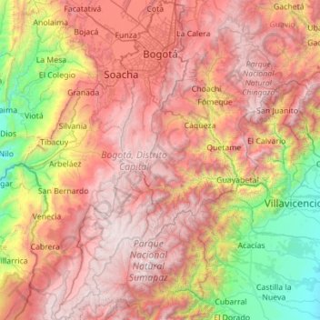
Name: Bogota, Capital District topographic map, elevation, terrain.
Location: Bogota, Capital District, RAP (Especial) Central, Colombia (3.73005 -74.45095 4.83702 -73.98590)
Average elevation: 2,183 m
Minimum elevation: 308 m
Maximum elevation: 4,222 m
Make a donation
Gear up for your next adventure:
As an Amazon Associate, this site earns from qualifying purchases at no extra cost to you.
Other topographic maps
Click on a map to view its topography, its elevation and its terrain.
Make a donation
Gear up for your next adventure:
As an Amazon Associate, this site earns from qualifying purchases at no extra cost to you.
Centro Experimental Gaviotas
Gaviotas has leveraged many forms of solar energy. They developed solar heating panels to provide hot water, which were installed in Gaviotas homes and housing developments in Medellín. The original design was not suited for Bogotá, however, since at 2,600 meters of altitude (9,000 ft) the city has a cooler…
Average elevation: 176 m
Make a donation
Gear up for your next adventure:
As an Amazon Associate, this site earns from qualifying purchases at no extra cost to you.
Floridablanca
Colombia > Santander > Floridablanca > Floridablanca
Floridablanca is situated at an altitude of about 925 metres (3,035 ft) in the Eastern Ranges of the Colombian Andes, though locally the topography varies greatly. To the east of the city the higher mountains of the Andes rise above the city, thrusted upwards by the north–south-trending Bucaramanga-Santa…
Average elevation: 1,091 m
Make a donation
Gear up for your next adventure:
As an Amazon Associate, this site earns from qualifying purchases at no extra cost to you.