Geolocate

Riddes topographic map

Click on the map to display elevation.

About this map

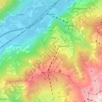
Name: Riddes topographic map, elevation, terrain.

Location: Riddes, Martigny, Wallis, Switzerland (46.09687 7.19640 46.18371 7.28057)

Average elevation: 1,410 m

Minimum elevation: 463 m

Maximum elevation: 2,993 m

Other topographic maps

Click on a map to view its topography, its elevation and its terrain.

Le Guercet

Switzerland > Wallis > Martigny > Martigny

Average elevation: 718 m

Ly

Switzerland > Wallis > Martigny > Trient

Average elevation: 2,234 m

Dugny

Switzerland > Wallis > Martigny > Ovronnaz

Average elevation: 1,074 m

La Tzoumaz

Switzerland > Wallis > Martigny

Average elevation: 1,467 m

Gear up for your next adventure:

🧭GPS Outdoor Watch - Smart watch for navigation and fitness tracking in nature
🗺️Topographic Maps - Detailed maps to explore trails, mountains, and wilderness areas
🧥Thermal Fleece Jacket - Versatile insulation for changing mountain temperatures
Lightweight Camping Tent - Portable shelter optimized for Canadian backcountry camping
🚲Handlebar Phone Mount - View topographic-map.com live while cycling

As an Amazon Associate, this site earns from qualifying purchases at no extra cost to you.