Geolocate

Ruxton topographic map

Click on the map to display elevation.

About this map

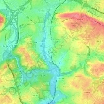
Name: Ruxton topographic map, elevation, terrain.

Location: Ruxton, Riderwood, Towson, Baltimore County, Maryland, 21139, United States (39.37804 -76.66486 39.41804 -76.62486)

Average elevation: 105 m

Minimum elevation: 64 m

Maximum elevation: 157 m

Other topographic maps

Click on a map to view its topography, its elevation and its terrain.

Towson

United States > Maryland > Baltimore County > Towson

Average elevation: 114 m

Lake Roland

United States > Maryland > Baltimore County > Towson > Ruxton

Average elevation: 99 m

Towson

United States > Maryland > Baltimore County > Towson

Average elevation: 114 m

Towson

United States > Maryland > Baltimore County > Towson

Average elevation: 114 m

Gear up for your next adventure:

🪜Heavy Duty Carabiners - Multi-use clips for securing gear to your backpack
🧥Fleece Jacket - Warm and lightweight jacket for layering
🛶Canoe Life Vest - Safety vest for water sports
Lightweight Backpacking Tent - Compact tent for efficient hiking trips
🧴Outdoor Sunscreen - High SPF protection for high-altitude UV exposure

As an Amazon Associate, this site earns from qualifying purchases at no extra cost to you.