Geolocate

Timonium topographic map

Click on the map to display elevation.

About this map

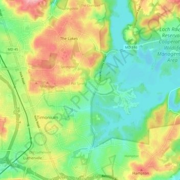
Name: Timonium topographic map, elevation, terrain.

Location: Timonium, Baltimore County, Maryland, United States (39.42849 -76.64629 39.46629 -76.55652)

Average elevation: 113 m

Minimum elevation: 67 m

Maximum elevation: 183 m

Gear up for your next adventure:

🪑Ultralight Camping Stool - Compact seating for rest stops during long hikes
🧭GPS Tracker - Track your location in remote areas safely
🌡️Emergency Mylar Blankets - Compact thermal protection for unexpected nights outdoors
🥾Waterproof Trail Shoes - Shoes designed to handle wet terrain
🥾Approach Shoes - Shoes designed for climbing approaches and rugged trails

As an Amazon Associate, this site earns from qualifying purchases at no extra cost to you.