Geolocate

Kingsville topographic map

Click on the map to display elevation.

About this map

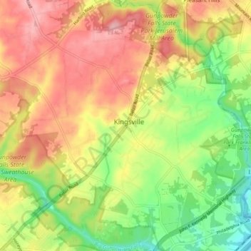
Name: Kingsville topographic map, elevation, terrain.

Location: Kingsville, Baltimore County, Maryland, 21087, United States (39.41602 -76.45652 39.47945 -76.38097)

Average elevation: 85 m

Minimum elevation: 9 m

Maximum elevation: 157 m

Gear up for your next adventure:

💧Reusable Water Bottle - Durable water bottles for hydration on trails
🛶Kayak Dry Bag - Waterproof storage for kayaking adventures
🥾Hiking Shorts - Breathable shorts suitable for summer hikes
🥽Outdoor Goggles - Protective eyewear for outdoor activities
🧭GPS Outdoor Watch - Smart watch for navigation and fitness tracking in nature

As an Amazon Associate, this site earns from qualifying purchases at no extra cost to you.