
Make a donation
Gear up for your next adventure:
As an Amazon Associate, this site earns from qualifying purchases at no extra cost to you.
Garden County topographic map
Click on the map to display elevation.
Make a donation
Gear up for your next adventure:
As an Amazon Associate, this site earns from qualifying purchases at no extra cost to you.
About this map
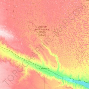
Name: Garden County topographic map, elevation, terrain.
Location: Garden County, Nebraska, United States (41.22105 -102.67921 42.00947 -101.98534)
Average elevation: 1,163 m
Minimum elevation: 990 m
Maximum elevation: 1,323 m
Make a donation
Gear up for your next adventure:
As an Amazon Associate, this site earns from qualifying purchases at no extra cost to you.
Other topographic maps
Click on a map to view its topography, its elevation and its terrain.
Missouri River
United States > Nebraska > Cedar County
Elevations in the watershed vary widely, ranging from just over 400 feet (120 m) at the Missouri's mouth to the 14,293-foot (4,357 m) summit of Mount Lincoln in central Colorado. The river drops 8,626 feet (2,629 m) from Brower's Spring, the farthest source. Although the plains of the watershed have extremely…
Average elevation: 368 m
Make a donation
Gear up for your next adventure:
As an Amazon Associate, this site earns from qualifying purchases at no extra cost to you.