
Make a donation
Gear up for your next adventure:
As an Amazon Associate, this site earns from qualifying purchases at no extra cost to you.
Narok West topographic map
Click on the map to display elevation.
Make a donation
Gear up for your next adventure:
As an Amazon Associate, this site earns from qualifying purchases at no extra cost to you.
About this map
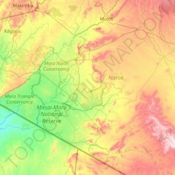
Name: Narok West topographic map, elevation, terrain.
Location: Narok West, Narok, 66601, Kenya (-1.83864 34.98884 -0.82970 35.78295)
Average elevation: 1,830 m
Minimum elevation: 1,387 m
Maximum elevation: 2,676 m
Make a donation
Gear up for your next adventure:
As an Amazon Associate, this site earns from qualifying purchases at no extra cost to you.
Other topographic maps
Click on a map to view its topography, its elevation and its terrain.
Narok
Kenya > Narok > Narok North > Narok Town ward
Narok (sometimes referred to as NauwongoTown) is a town west of Nairobi that supports Kenya's economy in south-west of the country, along the Great Rift Valley. Narok is the county capital of the Narok County and stands as the major centre of commerce in the county. Narok has a population of around 117, 607…
Average elevation: 1,920 m
Narok
Narok (sometimes referred to as Narok Town) is a town west of Nairobi that supports Kenya's economy in south-west of the country, along the Great Rift Valley. Narok is the district capital of the Narok County and stands as the major centre of commerce in the district. Narok has a population of around 40,000…
Average elevation: 1,904 m
Make a donation
Gear up for your next adventure:
As an Amazon Associate, this site earns from qualifying purchases at no extra cost to you.
Make a donation
Gear up for your next adventure:
As an Amazon Associate, this site earns from qualifying purchases at no extra cost to you.
Make a donation
Gear up for your next adventure:
As an Amazon Associate, this site earns from qualifying purchases at no extra cost to you.