
Gauteng topographic map
Interactive map
Click on the map to display elevation.
About this map
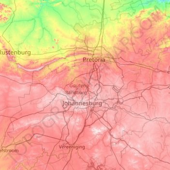
Name: Gauteng topographic map, elevation, terrain.
Location: Gauteng, South Africa (-26.92383 27.15634 -25.10961 29.09842)
Average elevation: 1,405 m
Minimum elevation: 914 m
Maximum elevation: 1,905 m
Gauteng's southern border is the Vaal River, which separates it from the Free State. It also borders on North West to the west, Limpopo to the north, and Mpumalanga to the east. Gauteng is the only landlocked province of South Africa without a foreign border. Most of Gauteng is on the Highveld, a high-altitude grassland (circa 1,500 m or 4,921 ft above sea level). Between Johannesburg and Pretoria, there are low parallel ridges and undulating hills, some part of the Magaliesberg Mountains and the Witwatersrand. The north of the province is more subtropical, due to its lower altitude and is mostly dry savanna habitat.
Other topographic maps
Click on a map to view its topography, its elevation and its terrain.
Maluti-a-Phofung Local Municipality
South Africa > Free State > Thabo Mofutsanyana District Municipality
Maluti-a-Phofung Local Municipality, Thabo Mofutsanyana District Municipality, Free State, South Africa
Average elevation: 1,733 m
Dzanani
South Africa > Limpopo > Vhembe District Municipality > Makhado Local Municipality
Dzanani, Makhado Local Municipality, Vhembe District Municipality, Limpopo, 0920, South Africa
Average elevation: 833 m
Bethelsdorp
South Africa > Eastern Cape > Nelson Mandela Bay Metropolitan Municipality
Bethelsdorp, Nelson Mandela Bay Metropolitan Municipality, Eastern Cape, 6059, South Africa
Average elevation: 85 m
Tongaat
South Africa > KwaZulu-Natal > eThekwini Metropolitan Municipality
Tongaat, eThekwini Metropolitan Municipality, KwaZulu-Natal, 4400, South Africa
Average elevation: 73 m
Durbanville
South Africa > Western Cape > City of Cape Town
Durbanville, City of Cape Town, Western Cape, 7550, South Africa
Average elevation: 157 m
Metsimaholo Local Municipality
South Africa > Free State > Fezile Dabi District Municipality
Metsimaholo Local Municipality, Fezile Dabi District Municipality, Free State, South Africa
Average elevation: 1,497 m
Cannon Rocks
South Africa > Eastern Cape > Sarah Baartman District Municipality > Ndlambe Local Municipality
Cannon Rocks, Ndlambe Local Municipality, Sarah Baartman District Municipality, Eastern Cape, South Africa
Average elevation: 35 m
Grasslands
South Africa > Free State > Mangaung Metropolitan Municipality
Grasslands, Mangaung Metropolitan Municipality, Free State, 9364, South Africa
Average elevation: 1,360 m
Sedibeng District Municipality
Sedibeng District Municipality, Gauteng, South Africa
Average elevation: 1,554 m
Melk River
South Africa > Eastern Cape > Sarah Baartman District Municipality > Blue Crane Route Local Municipality
Melk River, Blue Crane Route Local Municipality, Sarah Baartman District Municipality, Eastern Cape, South Africa
Average elevation: 699 m
Coffee Bay
South Africa > Eastern Cape > O.R. Tambo District Municipality > King Sabata Dalindyebo Local Municipality
Coffee Bay, King Sabata Dalindyebo Local Municipality, O.R. Tambo District Municipality, Eastern Cape, South Africa
Average elevation: 40 m
Klerksdorp
South Africa > North West > Dr Kenneth Kaunda District Municipality
Klerksdorp, Matlosana Local Municipality, Dr Kenneth Kaunda District Municipality, North West, 2570, South Africa
Average elevation: 1,346 m
Antjie Boom se Baken
South Africa > Northern Cape > Namakwa District Municipality > Hantam Local Municipality
Antjie Boom se Baken, Hantam Local Municipality, Namakwa District Municipality, Northern Cape, South Africa
Average elevation: 1,049 m
Komani
South Africa > Eastern Cape > Chris Hani District Municipality > Lukhanji Local Municipality
Komani, Lukhanji Local Municipality, Chris Hani District Municipality, Eastern Cape, 5319, South Africa
Average elevation: 1,149 m
Arniston
South Africa > Western Cape > Overberg District Municipality > Cape Agulhas Local Municipality
Arniston, Cape Agulhas Local Municipality, Overberg District Municipality, Western Cape, South Africa
Average elevation: 13 m
Jansenville
South Africa > Eastern Cape > Sarah Baartman District Municipality > Ikwezi Local Municipality
Jansenville, Ikwezi Local Municipality, Sarah Baartman District Municipality, Eastern Cape, South Africa
Average elevation: 448 m
Thaba Chweu Local Municipality
South Africa > Mpumalanga > Ehlanzeni District Municipality
Thaba Chweu Local Municipality, Ehlanzeni District Municipality, Mpumalanga, South Africa
Average elevation: 1,207 m
Flagstaff
South Africa > Eastern Cape > O.R. Tambo District Municipality > Ingquza Hill Local Municipality
Flagstaff, Ingquza Hill Local Municipality, O.R. Tambo District Municipality, Eastern Cape, South Africa
Average elevation: 837 m
Cape St. Francis
South Africa > Eastern Cape > Sarah Baartman District Municipality > Kouga Local Municipality
Cape St. Francis, Kouga Local Municipality, Sarah Baartman District Municipality, Eastern Cape, 6312, South Africa
Average elevation: 10 m
Msikaba River
South Africa > Eastern Cape > O.R. Tambo District Municipality
Msikaba River, O.R. Tambo District Municipality, Eastern Cape, South Africa
Average elevation: 462 m
City of Ekurhuleni Metropolitan Municipality
City of Ekurhuleni Metropolitan Municipality, Gauteng, South Africa
Average elevation: 1,588 m
Nyandeni Local Municipality
South Africa > Eastern Cape > O.R. Tambo District Municipality
Nyandeni Local Municipality, O.R. Tambo District Municipality, Eastern Cape, 5160, South Africa
Average elevation: 569 m
Germiston
South Africa > Gauteng > City of Ekurhuleni Metropolitan Municipality
Germiston, City of Ekurhuleni Metropolitan Municipality, Gauteng, 1401, South Africa
Average elevation: 1,635 m
De Vlugt
South Africa > Western Cape > Garden Route District Municipality > George Local Municipality
De Vlugt, George Local Municipality, Garden Route District Municipality, Western Cape, South Africa
Average elevation: 457 m
Cofimvaba
South Africa > Eastern Cape > Chris Hani District Municipality > Intsika Yethu Local Municipality
Cofimvaba, Intsika Yethu Local Municipality, Chris Hani District Municipality, Eastern Cape, South Africa
Average elevation: 997 m
Lusikisiki
South Africa > Eastern Cape > O.R. Tambo District Municipality > Ingquza Hill Local Municipality
Lusikisiki, Ingquza Hill Local Municipality, O.R. Tambo District Municipality, Eastern Cape, South Africa
Average elevation: 563 m
Cape Town
South Africa > Western Cape > City of Cape Town
Cape Town, City of Cape Town, Western Cape, 8001, South Africa
Average elevation: 53 m
Matjiesfontein
South Africa > Western Cape > Central Karoo District Municipality > Laingsburg Local Municipality
Matjiesfontein, Laingsburg Local Municipality, Central Karoo District Municipality, Western Cape, 6901, South Africa
Average elevation: 972 m
Fernie
South Africa > Mpumalanga > Gert Sibande > Albert Luthuli Local Municipality
Fernie, Albert Luthuli Local Municipality, Gert Sibande, Mpumalanga, South Africa
Average elevation: 1,449 m
Witzenberg Local Municipality
South Africa > Western Cape > Cape Winelands District Municipality
Witzenberg Local Municipality, Cape Winelands District Municipality, Western Cape, South Africa
Average elevation: 793 m
Wet Lands
South Africa > Western Cape > Cape Winelands District Municipality > Stellenbosch Local Municipality > Stellenbosch
Wet Lands, Stellenbosch Ward 17, Stellenbosch, Stellenbosch Local Municipality, Cape Winelands District Municipality, Western Cape, South Africa
Average elevation: 160 m
Umlazi
South Africa > KwaZulu-Natal > eThekwini Metropolitan Municipality
Umlazi, eThekwini Metropolitan Municipality, KwaZulu-Natal, 4066, South Africa
Average elevation: 100 m
Roodepoort
South Africa > Gauteng > City of Johannesburg Metropolitan Municipality
Roodepoort, City of Johannesburg Metropolitan Municipality, Gauteng, South Africa
Average elevation: 1,593 m
Stellenbosch
South Africa > Western Cape > Cape Winelands District Municipality > Stellenbosch Local Municipality
Stellenbosch, Stellenbosch Local Municipality, Cape Winelands District Municipality, Western Cape, 7599, South Africa
Average elevation: 222 m
Hillcrest
South Africa > KwaZulu-Natal > eThekwini Metropolitan Municipality
Hillcrest, eThekwini Metropolitan Municipality, KwaZulu-Natal, 3651, South Africa
Average elevation: 625 m
Nama Khoi Local Municipality
South Africa > Northern Cape > Namakwa District Municipality
Nama Khoi Local Municipality, Namakwa District Municipality, Northern Cape, South Africa
Average elevation: 703 m
Dikgatlong Local Municipality
South Africa > Northern Cape > Frances Baard District Municipality
Dikgatlong Local Municipality, Frances Baard District Municipality, Northern Cape, South Africa
Average elevation: 1,253 m
Lime Acres
South Africa > Northern Cape > ZF Mgcawu District Municipality > Kgatelopele Local Municipality
Lime Acres, Kgatelopele Local Municipality, ZF Mgcawu District Municipality, Northern Cape, South Africa
Average elevation: 1,496 m
Hambrook
South Africa > KwaZulu-Natal > Uthukela District Municipality > Okhahlamba Local Municipality
Hambrook, Okhahlamba Local Municipality, Uthukela District Municipality, KwaZulu-Natal, South Africa
Average elevation: 1,128 m
Matatiele Local Municipality
South Africa > Eastern Cape > Alfred Nzo District Municipality
Matatiele Local Municipality, Alfred Nzo District Municipality, Eastern Cape, South Africa
Average elevation: 1,719 m
Signal Hill
South Africa > Western Cape > City of Cape Town > Cape Town
Signal Hill, Cape Town, City of Cape Town, Western Cape, 8051, South Africa
Average elevation: 87 m
Jeffreys Bay
South Africa > Eastern Cape > Sarah Baartman District Municipality > Kouga Local Municipality
Jeffreys Bay, Kouga Local Municipality, Sarah Baartman District Municipality, Eastern Cape, 6330, South Africa
Average elevation: 30 m
Mbombela
South Africa > Mpumalanga > Ehlanzeni District Municipality
Mbombela, Ehlanzeni District Municipality, Mpumalanga, 1201, South Africa
Average elevation: 833 m
eThekwini Metropolitan Municipality
eThekwini Metropolitan Municipality, KwaZulu-Natal, South Africa
Average elevation: 289 m
Swinburne
South Africa > Free State > Thabo Mofutsanyana District Municipality > Maluti-a-Phofung Local Municipality
Swinburne, Maluti-a-Phofung Local Municipality, Thabo Mofutsanyana District Municipality, Free State, South Africa
Average elevation: 1,678 m
Franschhoek
South Africa > Western Cape > Cape Winelands District Municipality > Stellenbosch Local Municipality
Franschhoek, Stellenbosch Local Municipality, Cape Winelands District Municipality, Western Cape, 7690, South Africa
Average elevation: 502 m