
Make a donation
Gear up for your next adventure:
As an Amazon Associate, this site earns from qualifying purchases at no extra cost to you.
Nama Khoi Local Municipality topographic map
Click on the map to display elevation.
Make a donation
Gear up for your next adventure:
As an Amazon Associate, this site earns from qualifying purchases at no extra cost to you.
About this map
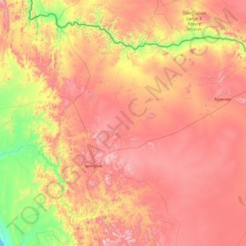
Name: Nama Khoi Local Municipality topographic map, elevation, terrain.
Average elevation: 703 m
Minimum elevation: 0 m
Maximum elevation: 1,516 m
Make a donation
Gear up for your next adventure:
As an Amazon Associate, this site earns from qualifying purchases at no extra cost to you.
Other topographic maps
Click on a map to view its topography, its elevation and its terrain.
Sutherland
South Africa > Northern Cape > Namakwa District Municipality > Karoo Hoogland Local Municipality
Average elevation: 1,533 m
Antjie Boom se Baken
South Africa > Northern Cape > Namakwa District Municipality > Hantam Local Municipality
Average elevation: 1,049 m
Fraserburg
South Africa > Northern Cape > Namakwa District Municipality > Karoo Hoogland Local Municipality
Fraserburg is situated at an altitude of 1,385 metres (4,544 ft) above sea level on a high Karoo plateau, north of the Nuweveld Mountains.
Average elevation: 1,268 m