
Western Cape topographic map
Interactive map
Click on the map to display elevation.
Western Cape
The province is topographically exceptionally diverse. Most of the province falls within the Cape Fold Belt, a set of nearly parallel ranges of sandstone folded mountains of Cambrian-Ordovician age (the age of the rocks is from 510 to about 330 million years ago; their folding into mountains occurred about 350 to about 270 million years ago). The height of the mountain peaks in the different ranges varies from 1000 m to 2300 m. The valleys between ranges are generally very fertile, as they contain the weathered loamy soils of the Bokkeveld mudstones (see the diagrams below).
About this map
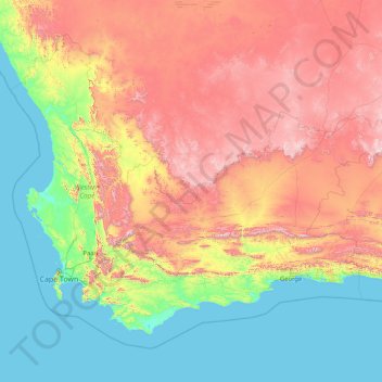
Name: Western Cape topographic map, elevation, terrain.
Location: Western Cape, South Africa (-35.03376 17.56879 -30.43026 24.22241)
Average elevation: 581 m
Minimum elevation: 0 m
Maximum elevation: 2,197 m
Other topographic maps
Click on a map to view its topography, its elevation and its terrain.
Empangeni
South Africa > KwaZulu-Natal > King Cetswayo District Municipality > uMhlathuze Local Municipality
Average elevation: 89 m
Hermanus
South Africa > Western Cape > Overberg District Municipality > Overstrand Local Municipality
Average elevation: 87 m
Graaff-Reinet
South Africa > Sarah Baartman District Municipality > Camdeboo Local Municipality
Average elevation: 873 m
Sutherland
South Africa > Northern Cape > Namakwa District Municipality > Karoo Hoogland Local Municipality
Average elevation: 1,533 m
Tierkloof
South Africa > Western Cape > West Coast District Municipality > Saldanha Bay Local Municipality
Average elevation: 92 m
Dzanani
South Africa > Limpopo > Vhembe District Municipality > Makhado Local Municipality
Average elevation: 833 m
Bethelsdorp
South Africa > Eastern Cape > Nelson Mandela Bay Metropolitan Municipality
Average elevation: 85 m
Durbanville
South Africa > Western Cape > City of Cape Town
Durbanville is situated in the northern suburbs of Cape Town, approximately 28 kilometres (17.4 mi) north-east of the city, bordered by Bellville to the south, Brackenfell to the south-east and Kraaifontein to the east. It lies at an altitude of between 100 m (328 ft) to 240 m (787 ft), in the vast rolling…
Average elevation: 157 m
Cannon Rocks
South Africa > Eastern Cape > Sarah Baartman District Municipality > Ndlambe Local Municipality
Average elevation: 35 m
Melk River
South Africa > Eastern Cape > Sarah Baartman District Municipality > Blue Crane Route Local Municipality
Average elevation: 699 m
Coffee Bay
South Africa > Eastern Cape > O.R. Tambo District Municipality > King Sabata Dalindyebo Local Municipality
Average elevation: 40 m
Klerksdorp
South Africa > North West > Dr Kenneth Kaunda District Municipality
Average elevation: 1,346 m
Antjie Boom se Baken
South Africa > Northern Cape > Namakwa District Municipality > Hantam Local Municipality
Average elevation: 1,049 m
Arniston
South Africa > Western Cape > Overberg District Municipality > Cape Agulhas Local Municipality
Average elevation: 13 m
Komani
South Africa > Eastern Cape > Chris Hani District Municipality > Lukhanji Local Municipality
Average elevation: 1,147 m
Jansenville
South Africa > Eastern Cape > Sarah Baartman District Municipality > Ikwezi Local Municipality
Average elevation: 448 m
Flagstaff
South Africa > Eastern Cape > O.R. Tambo District Municipality > Ingquza Hill Local Municipality
Average elevation: 837 m
Cape St. Francis
South Africa > Eastern Cape > Sarah Baartman District Municipality > Kouga Local Municipality
Average elevation: 10 m
Germiston
South Africa > Gauteng > City of Ekurhuleni Metropolitan Municipality
Average elevation: 1,635 m
Fernie
South Africa > Mpumalanga > Gert Sibande > Albert Luthuli Local Municipality
Average elevation: 1,449 m
De Vlugt
South Africa > Western Cape > Garden Route District Municipality > George Local Municipality
Average elevation: 457 m
Matjiesfontein
South Africa > Western Cape > Central Karoo District Municipality > Laingsburg Local Municipality
Average elevation: 972 m
Lusikisiki
South Africa > Eastern Cape > O.R. Tambo District Municipality > Ingquza Hill Local Municipality
Average elevation: 563 m
Cofimvaba
South Africa > Eastern Cape > Chris Hani District Municipality > Intsika Yethu Local Municipality
Average elevation: 997 m
Hillcrest
South Africa > KwaZulu-Natal > eThekwini Metropolitan Municipality
Hillcrest is situated in the Upper Highway Area of Durban, approximately 32 kilometres (20 mi) north-west of the city and is bordered by Gillitts and Everton to the east, Waterfall to the north-east and Botha's Hill and Assagay to the north-west. It lies at an altitude of approximately 680 m (2231 ft) above…
Average elevation: 625 m
Wet Lands
South Africa > Western Cape > Cape Winelands District Municipality > Stellenbosch Local Municipality > Stellenbosch
Average elevation: 160 m
Roodepoort
South Africa > Gauteng > City of Johannesburg Metropolitan Municipality
Average elevation: 1,593 m
Stellenbosch
South Africa > Western Cape > Cape Winelands District Municipality > Stellenbosch Local Municipality
Stellenbosch is 53 km (33 mi) east of Cape Town via National Route N1. Stellenbosch is in a hilly region of the Cape Winelands, and is sheltered in a valley at an average elevation of 136 m (446 ft), flanked on the west by Papegaaiberg (Afrikaans: Parrot Mountain), which is actually a hill. To the south is…
Average elevation: 222 m
Lime Acres
South Africa > Northern Cape > ZF Mgcawu District Municipality > Kgatelopele Local Municipality
Average elevation: 1,496 m
Hambrook
South Africa > KwaZulu-Natal > Uthukela District Municipality > Okhahlamba Local Municipality
Average elevation: 1,128 m
Franschhoek
South Africa > Western Cape > Cape Winelands District Municipality > Stellenbosch Local Municipality
Average elevation: 502 m
Swinburne
South Africa > Free State > Thabo Mofutsanyana District Municipality > Maluti-a-Phofung Local Municipality
Average elevation: 1,678 m
Fraserburg
South Africa > Northern Cape > Namakwa District Municipality > Karoo Hoogland Local Municipality
Fraserburg is situated at an altitude of 1,385 metres (4,544 ft) above sea level on a high Karoo plateau, north of the Nuweveld Mountains.
Average elevation: 1,268 m
Himalya Street Park
South Africa > Gauteng > City of Tshwane Metropolitan Municipality > Pretoria
Average elevation: 1,456 m
Kariega
South Africa > Eastern Cape > Nelson Mandela Bay Metropolitan Municipality
Average elevation: 89 m
Riebeek-Wes
South Africa > Western Cape > West Coast District Municipality > Swartland Local Municipality > Riebeek-Wes
Average elevation: 262 m
Roodepoort
South Africa > Gauteng > City of Johannesburg Metropolitan Municipality > Roodepoort
Average elevation: 1,612 m
Benoni
South Africa > Gauteng > City of Ekurhuleni Metropolitan Municipality
Average elevation: 1,645 m
Phoenix
South Africa > KwaZulu-Natal > eThekwini Metropolitan Municipality > Phoenix
Average elevation: 103 m
Mahikeng
South Africa > North West > Ngaka Modiri Molema District Municipality > Mahikeng
Located close to South Africa's border with Botswana, Mahikeng is 1,400 km (870 mi) northeast of Cape Town and 260 km (160 mi) west of Johannesburg. In 2001, it had a population of 49,300. In 2007, Mahikeng was reported to have a population of 250,000 of which the CBD constitutes between 69,000 and 75,000. It…
Average elevation: 1,321 m
Springbok
South Africa > Northern Cape > Namakwa District Municipality > Nama Khoi Local Municipality > Springbok
Average elevation: 926 m
Wilderness
South Africa > Western Cape > George Local Municipality > Wilderness
Average elevation: 69 m
Stellenbosch
South Africa > Western Cape > Stellenbosch Local Municipality > Stellenbosch
Stellenbosch is 53 km (33 mi) east of Cape Town via National Route N1. Stellenbosch is in a hilly region of the Cape Winelands, and is sheltered in a valley at an average elevation of 136 m (446 ft), flanked on the west by Papegaaiberg (Afrikaans: Parrot Mountain), which is actually a hill. To the south is…
Average elevation: 287 m
Mount Currie
South Africa > KwaZulu-Natal > Greater Kokstad Local Municipality
Average elevation: 1,856 m
Hopetown
South Africa > Northern Cape > Thembelihle Local Municipality > Hopetown
Average elevation: 1,101 m
Nuwejaarspruit
South Africa > Free State > Maluti-a-Phofung Local Municipality
Average elevation: 1,657 m
Rooigrond
South Africa > North West > Mahikeng Local Municipality > Rooigrond
Average elevation: 1,408 m
Durban North
South Africa > KwaZulu-Natal > eThekwini Metropolitan Municipality
Average elevation: 41 m
Richards Bay
South Africa > KwaZulu-Natal > King Cetswayo District Municipality > Richards Bay
Average elevation: 31 m
Alice
South Africa > Eastern Cape > Amathole District Municipality > Nkonkobe Local Municipality > Alice
Average elevation: 586 m
East London
South Africa > Eastern Cape > Buffalo City Metropolitan Municipality
Average elevation: 72 m
Rainfall Dam
South Africa > Free State > Thabo Mofutsanyana District Municipality > Maluti-a-Phofung Local Municipality
Average elevation: 1,707 m
Underberg
South Africa > KwaZulu-Natal > Sisonke District Municipality > Kwa Sani Local Municipality > Underberg
Average elevation: 1,552 m
Botha
South Africa > Western Cape > Cape Winelands District Municipality > Witzenberg Local Municipality > Botha
Average elevation: 322 m
City of Johannesburg Metropolitan Municipality
South Africa > Gauteng > City of Johannesburg Metropolitan Municipality
Average elevation: 1,615 m
Aston Bay
South Africa > Eastern Cape > Sarah Baartman District Municipality > Kouga Local Municipality > Aston Bay
Average elevation: 12 m
Rustenburg
South Africa > North West > Bojanala Platinum District Municipality > Rustenburg
Rustenburg has a humid subtropical climate (Köppen Cwa), with a relatively high degree of diurnal temperature variation due to the high elevation. It has very warm summers (from December to February) and mild winters (from June to August). Due to the altitude, summers are not quite as hot as one might expect.…
Average elevation: 1,217 m