
Make a donation
Gear up for your next adventure:
As an Amazon Associate, this site earns from qualifying purchases at no extra cost to you.
Msikaba River topographic map
Click on the map to display elevation.
Make a donation
Gear up for your next adventure:
As an Amazon Associate, this site earns from qualifying purchases at no extra cost to you.
About this map
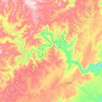
Name: Msikaba River topographic map, elevation, terrain.
Average elevation: 462 m
Minimum elevation: 75 m
Maximum elevation: 741 m
Make a donation
Gear up for your next adventure:
As an Amazon Associate, this site earns from qualifying purchases at no extra cost to you.
Other topographic maps
Click on a map to view its topography, its elevation and its terrain.
Flagstaff
South Africa > Eastern Cape > O.R. Tambo District Municipality > Ingquza Hill Local Municipality
Average elevation: 837 m
Coffee Bay
South Africa > Eastern Cape > O.R. Tambo District Municipality > King Sabata Dalindyebo Local Municipality
Average elevation: 40 m
Lusikisiki
South Africa > Eastern Cape > O.R. Tambo District Municipality > Ingquza Hill Local Municipality
Average elevation: 563 m
Nyandeni Local Municipality
South Africa > Eastern Cape > O.R. Tambo District Municipality
Average elevation: 569 m
Make a donation
Gear up for your next adventure:
As an Amazon Associate, this site earns from qualifying purchases at no extra cost to you.