
Maluti-a-Phofung Local Municipality topographic map
Interactive map
Click on the map to display elevation.
About this map
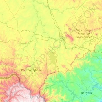
Name: Maluti-a-Phofung Local Municipality topographic map, elevation, terrain.
Average elevation: 1,733 m
Minimum elevation: 1,033 m
Maximum elevation: 3,282 m
Other topographic maps
Click on a map to view its topography, its elevation and its terrain.
Swinburne
South Africa > Free State > Thabo Mofutsanyana District Municipality > Maluti-a-Phofung Local Municipality
Average elevation: 1,678 m
Rainfall Dam
South Africa > Free State > Thabo Mofutsanyana District Municipality > Maluti-a-Phofung Local Municipality
Average elevation: 1,707 m