
Make a donation
Gear up for your next adventure:
As an Amazon Associate, this site earns from qualifying purchases at no extra cost to you.
Anantnag district topographic map
Click on the map to display elevation.
Make a donation
Gear up for your next adventure:
As an Amazon Associate, this site earns from qualifying purchases at no extra cost to you.
Anantnag district
"Sir Walter Lawrence writes in his book The Valley of Kashmir that in latitude Kashmir corresponds with Peshawar, Baghdad and Damascus in Asia: with Fez in Morocco: and South Carolina in America, but it presents none of the characteristics of those countries. People have linked the climate of Kashmir to that of Switzerland until the end of May, and of Southern France in July and August. But it is impossible to speak of Kashmir as possessing any one climate or group of characteristics. Every hundred feet of elevation brings some new phase of climate and of vegetation."
Make a donation
Gear up for your next adventure:
As an Amazon Associate, this site earns from qualifying purchases at no extra cost to you.
About this map
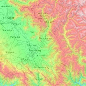
Name: Anantnag district topographic map, elevation, terrain.
Location: Anantnag district, Jammu and Kashmir, India (33.36373 75.02822 34.25580 75.59470)
Average elevation: 2,830 m
Minimum elevation: 1,218 m
Maximum elevation: 5,869 m
Make a donation
Gear up for your next adventure:
As an Amazon Associate, this site earns from qualifying purchases at no extra cost to you.
Other topographic maps
Click on a map to view its topography, its elevation and its terrain.
Nowshera
India > Jammu and Kashmir > Nowshehra Tehsil
Given its spatial and demographic extent, Nowshera has been given the status of a Sub-District. It is a beautiful place with a number of tourist attractions including the fort of Mangla Devi, holy cave temple of Mangla Mata, Central Gurudwara of Sikhs in Nonial, Qila Darhal and other Dargahs and temples. The…
Average elevation: 668 m
Make a donation
Gear up for your next adventure:
As an Amazon Associate, this site earns from qualifying purchases at no extra cost to you.
Make a donation
Gear up for your next adventure:
As an Amazon Associate, this site earns from qualifying purchases at no extra cost to you.
Rajouri
India > Jammu and Kashmir > Rajauri
Rajouri is located at 33°23′N 74°18′E / 33.38°N 74.3°E / 33.38; 74.3. It has an average elevation of 915 metres (3001 feet).
Average elevation: 1,038 m
Make a donation
Gear up for your next adventure:
As an Amazon Associate, this site earns from qualifying purchases at no extra cost to you.
Make a donation
Gear up for your next adventure:
As an Amazon Associate, this site earns from qualifying purchases at no extra cost to you.
Katra
India > Jammu and Kashmir > Reasi > Katra
Katra is located at 32°59′N 74°57′E / 32.98°N 74.95°E / 32.98; 74.95. It has an average elevation of 875 metres (2,474 feet). The Banganga River passes through the village.
Average elevation: 993 m