
Make a donation
Gear up for your next adventure:
As an Amazon Associate, this site earns from qualifying purchases at no extra cost to you.
Seefeld in Tirol topographic map
Click on the map to display elevation.
Make a donation
Gear up for your next adventure:
As an Amazon Associate, this site earns from qualifying purchases at no extra cost to you.
About this map
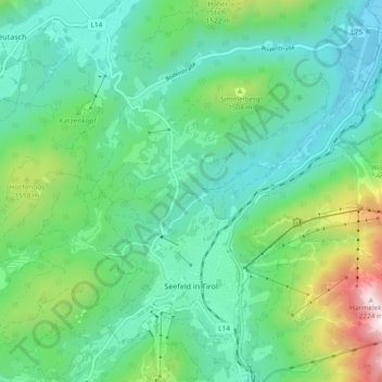
Name: Seefeld in Tirol topographic map, elevation, terrain.
Location: Seefeld in Tirol, Bezirk Innsbruck-Land, Tyrol, 6100, Austria (47.31939 11.16352 47.37000 11.25692)
Average elevation: 1,303 m
Minimum elevation: 1,004 m
Maximum elevation: 2,236 m
Make a donation
Gear up for your next adventure:
As an Amazon Associate, this site earns from qualifying purchases at no extra cost to you.
Other topographic maps
Click on a map to view its topography, its elevation and its terrain.
Hoher Burgstall
Austria > Tyrol > Bezirk Innsbruck-Land > Neustift im Stubaital
Average elevation: 2,142 m
Make a donation
Gear up for your next adventure:
As an Amazon Associate, this site earns from qualifying purchases at no extra cost to you.
Make a donation
Gear up for your next adventure:
As an Amazon Associate, this site earns from qualifying purchases at no extra cost to you.
Elferspitze
Austria > Tyrol > Bezirk Innsbruck-Land > Neustift im Stubaital
Average elevation: 1,978 m
Make a donation
Gear up for your next adventure:
As an Amazon Associate, this site earns from qualifying purchases at no extra cost to you.
Make a donation
Gear up for your next adventure:
As an Amazon Associate, this site earns from qualifying purchases at no extra cost to you.
Axamer Lizum
Austria > Tyrol > Bezirk Innsbruck-Land > Gemeinde Axams > Axamer Lizum
Average elevation: 1,858 m
Make a donation
Gear up for your next adventure:
As an Amazon Associate, this site earns from qualifying purchases at no extra cost to you.