Geolocate

Corridonia topographic map

Click on the map to display elevation.

About this map
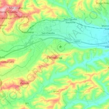
Name: Corridonia topographic map, elevation, terrain.

Location: Corridonia, Macerata, Marche, 62014, Italy (43.21123 13.41609 43.29211 13.57283)

Average elevation: 138 m

Minimum elevation: 50 m

Maximum elevation: 327 m

Other topographic maps

Click on a map to view its topography, its elevation and its terrain.

Collina

Italy > Marche > Macerata > Castelraimondo > Collina

Average elevation: 411 m

Appennino

Italy > Marche > Macerata > Pieve Torina

Average elevation: 868 m

Castiglione

Italy > Marche > Macerata > Caldarola

Average elevation: 521 m

Podalla

Italy > Marche > Macerata > Fiastra > Podalla

Average elevation: 898 m

Pitino

Italy > Marche > Macerata > San Severino Marche

Average elevation: 351 m

Pozzuolo

Italy > Marche > Macerata > Camerino > Pozzuolo

Average elevation: 656 m

Gear up for your next adventure:

🧴Outdoor Sunscreen - High SPF protection for high-altitude UV exposure
🕯️Camping Lantern - Illuminates your entire campsite with high-efficiency LEDs
🥾Hiking Shorts - Breathable shorts suitable for summer hikes
💧Hydration Bladder - Hands-free hydration solution for long treks
⛺Bushcraft Tarp - Versatile emergency shelter or gear protection

As an Amazon Associate, this site earns from qualifying purchases at no extra cost to you.