
El Peñol topographic map
Click on the map to display elevation.
About this map
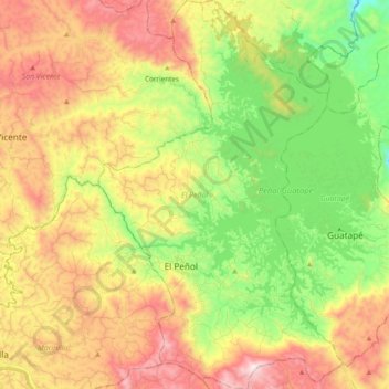
Name: El Peñol topographic map, elevation, terrain.
Average elevation: 2,051 m
Minimum elevation: 1,650 m
Maximum elevation: 2,541 m
Other topographic maps
Click on a map to view its topography, its elevation and its terrain.
Medellín
Colombia > Antioquia > Medellín
El valle de Aburrá posee una extensión de 1.152 km² que hacen parte de la cuenca del río Medellín, principal arteria fluvial que cruza la región de sur a norte. La conformación del Valle de Aburrá es el resultado de la unidad geográfica determinada por la cuenca del río Medellín y por una serie de…
Average elevation: 2,098 m
Sabaneta
Colombia > Antioquia > Sabaneta
Su topografía varía de relieves planos y ligeramente ondulados hasta lugares con altas pendientes. Las principales alturas son el alto Piedras Blancas (2650 m s. n. m.) en La Romera, la Cuchilla Santa Teresa (2200 m s. n. m.), el cerro de Los Gallinazos en Pan de Azúcar (1800 m s. n. m.), el cerro Morrón,…
Average elevation: 1,787 m
Girardota
Colombia > Antioquia > Girardota
El municipio de Girardota se encuentra localizado al norte del Valle de Aburrá, cuenta con un área de 82.56 km² de los cuales 3.07 km² corresponden a suelo urbano y 79.49 km² a suelo rural y hace parte del área metropolitana de la ciudad de Medellín. Su superficie (área) urbana de 3.07 km² aún no…
Average elevation: 1,720 m
Reserva Natural de la Sociedad Civil La Zafra
Colombia > Antioquia > San Carlos
Average elevation: 1,192 m
Zona Forestal Rieles cerro El Picacho.
Colombia > Antioquia > Medellín > El Picacho
Average elevation: 1,950 m
Santa Bárbara
Colombia > Antioquia > Santa Bárbara
Su topografía tiene marcadas semejanzas con la ciudad española de Granada. Muy pocas poblaciones de Antioquia disponen de la hermosa panorámica de esta tierra bañada por un sol ardiente, y rodeada de preciosos paisajes. Los fotógrafos que la visitan gozan con la variedad de sus picachos y valles lejanos.
Average elevation: 1,303 m
Santa Elena
Colombia > Antioquia > Medellín
Hace parte del altiplano oriental de Antioquia y ladera oriental de Medellín. Presenta una topografía de suave a moderadamente pendiente, conformada por colinas bajas y redondeadas, bien drenadas; Es un clima tropical húmedo con influencia de montaña, con una temperatura promedio de 14.5 °C y una humedad…
Average elevation: 2,547 m
Cerro El Volador
Colombia > Antioquia > Medellín
Desde esta época se desarrolló el "Ecoparque Cerro El Volador", que tiene como principal objetivo en cuanto al aspecto arqueológico, rescatar, conservar y difundir "in situ" estas evidencias culturales. Además, contribuir a la recreación de la ciudadanía, pues en este lugar se pueden desarrollar…
Average elevation: 1,500 m