Geolocate

Girardota topographic map

Click on the map to display elevation.

Girardota

El municipio de Girardota se encuentra localizado al norte del Valle de Aburrá, cuenta con un área de 82.56 km² de los cuales 3.07 km² corresponden a suelo urbano y 79.49 km² a suelo rural y hace parte del área metropolitana de la ciudad de Medellín. Su superficie (área) urbana de 3.07 km² aún no tiene una conurbación; como la mayoría de los municipios que conforman el área metropolitana. La cabecera cuenta con una temperatura de 22 °C y una altitud promedio 1425 m s. n. m.

Wikipedia (CC-BY-SA 3.0)

About this map

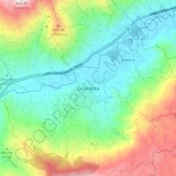
Name: Girardota topographic map, elevation, terrain.

Location: Girardota, Valle de Aburrá, Antioquia, RAP del Agua y la Montaña, 051037, Colombia (6.33738 -75.48598 6.41738 -75.40598)

Average elevation: 1,720 m

Minimum elevation: 1,309 m

Maximum elevation: 2,585 m

Other topographic maps

Click on a map to view its topography, its elevation and its terrain.

La Meseta

Colombia > Antioquia > Girardota

Average elevation: 1,529 m

El Barro

Colombia > Antioquia > Girardota

Average elevation: 1,625 m

Gear up for your next adventure:

🛏️Sleeping Bag - Warm and compact sleeping bags for outdoor camping
Camping Coffee Maker - Brew fresh coffee anywhere on the topographic map
🥫Freeze-Dried Meals - Lightweight, high-calorie nutrition for multi-day treks
🥾Light Trekking Boots - Supportive boots for multi-day treks
🧣Merino Neck Gaiter - Protects against wind, sun, and cold at high altitudes

As an Amazon Associate, this site earns from qualifying purchases at no extra cost to you.