Geolocate

Turbo topographic map

Click on the map to display elevation.

About this map

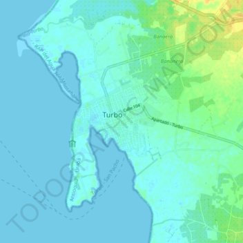
Name: Turbo topographic map, elevation, terrain.

Location: Turbo, Urabá, Antioquia, Colombia (7.93508 -76.88855 8.25508 -76.56855)

Average elevation: 51 m

Minimum elevation: -2 m

Maximum elevation: 661 m

Gear up for your next adventure:

🔭Outdoor Binoculars - Lightweight binoculars for birdwatching and hiking
👖Convertible Hiking Pants - Zip-off legs to adapt to changing weather conditions
Bushcraft Tarp - Versatile emergency shelter or gear protection
💧Hydration Bladder - Hands-free hydration solution for long treks
👟Leg Gaiters - Keep debris, mud, and snow out of your boots

As an Amazon Associate, this site earns from qualifying purchases at no extra cost to you.