
Make a donation
Gear up for your next adventure:
As an Amazon Associate, this site earns from qualifying purchases at no extra cost to you.
Santa Bárbara topographic map
Click on the map to display elevation.
Make a donation
Gear up for your next adventure:
As an Amazon Associate, this site earns from qualifying purchases at no extra cost to you.
Santa Bárbara
Su topografía tiene marcadas semejanzas con la ciudad española de Granada. Muy pocas poblaciones de Antioquia disponen de la hermosa panorámica de esta tierra bañada por un sol ardiente, y rodeada de preciosos paisajes. Los fotógrafos que la visitan gozan con la variedad de sus picachos y valles lejanos.
Make a donation
Gear up for your next adventure:
As an Amazon Associate, this site earns from qualifying purchases at no extra cost to you.
About this map
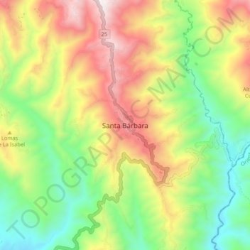
Name: Santa Bárbara topographic map, elevation, terrain.
Average elevation: 1,303 m
Minimum elevation: 753 m
Maximum elevation: 2,034 m
Make a donation
Gear up for your next adventure:
As an Amazon Associate, this site earns from qualifying purchases at no extra cost to you.