Geolocate

Santa Ines topographic map

Click on the map to display elevation.

About this map

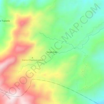
Name: Santa Ines topographic map, elevation, terrain.

Location: Santa Ines, San Carlos, Oriente, Antioquia, RAP del Agua y la Montaña, Colombia (6.11547 -75.02911 6.15547 -74.98911)

Average elevation: 1,536 m

Minimum elevation: 1,235 m

Maximum elevation: 1,945 m

Other topographic maps

Click on a map to view its topography, its elevation and its terrain.

La Leona

Colombia > Antioquia > San Carlos

Average elevation: 1,255 m

Gear up for your next adventure:

🛁Quick-Dry Microfiber Towel - Space-saving towel that dries rapidly on the move
🌬️Windproof Camp Stove - Efficient cooking even on exposed mountain peaks
🥾Hiking Gaiters - Protect legs and shoes from mud, snow, and debris
🛶Kayak Accessories - Essential gear for safe and fun kayaking adventures
🧥Softshell Hiking Jacket - The perfect balance of wind protection and breathability

As an Amazon Associate, this site earns from qualifying purchases at no extra cost to you.