
Chirang topographic map
Interactive map
Click on the map to display elevation.
About this map
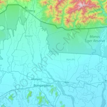
Name: Chirang topographic map, elevation, terrain.
Location: Chirang, Assam, Inde (26.38639 90.33697 26.90464 90.96235)
Average elevation: 216 m
Minimum elevation: 36 m
Maximum elevation: 2,257 m
Other topographic maps
Click on a map to view its topography, its elevation and its terrain.
Triangular Pond
Inde > Assam > Golaghat > Golaghat
Triangular Pond, Amolapatty Region — Amolapatty Old, AMOLAPATTY — OLD, Golaghat, Assam, 785621, Inde
Average elevation: 100 m