
Lala topographic map
Interactive map
Click on the map to display elevation.
About this map
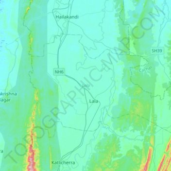
Name: Lala topographic map, elevation, terrain.
Location: Lala, Hailakandi, Assam, Inde (24.50644 92.50226 24.65962 92.78021)
Average elevation: 38 m
Minimum elevation: 12 m
Maximum elevation: 245 m
Other topographic maps
Click on a map to view its topography, its elevation and its terrain.
Triangular Pond
Inde > Assam > Golaghat > Golaghat
Triangular Pond, Amolapatty Region — Amolapatty Old, AMOLAPATTY — OLD, Golaghat, Assam, 785621, Inde
Average elevation: 100 m