Geolocate

Aller topographic map

Click on the map to display elevation.

About this map

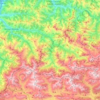
Name: Aller topographic map, elevation, terrain.

Location: Aller, Asturias, Spain (43.01835 -5.79028 43.19331 -5.38291)

Average elevation: 1,109 m

Minimum elevation: 203 m

Maximum elevation: 2,167 m

Other topographic maps

Click on a map to view its topography, its elevation and its terrain.

El Retornu

Spain > Asturias > Piloña

Average elevation: 592 m

La Barganiza

Spain > Asturias > Siero

Average elevation: 199 m

Liares

Spain > Asturias > Ibias

Average elevation: 713 m

Mones

Spain > Asturias > Valdés

Average elevation: 473 m

Avín

Spain > Asturias > Onís > Benia de Onís

Average elevation: 393 m

El Ferrol

Spain > Asturias > Castropol

Average elevation: 39 m

Sotrondio

Spain > Asturias > Samartín del Rei Aurelio

Average elevation: 424 m

Boriñes

Spain > Asturias > Piloña

Average elevation: 310 m

Siecha

Spain > Asturias > Cangas del Narcea

Average elevation: 892 m

L'Arquera

Spain > Asturias > Oviedo > L'Arquera

Average elevation: 224 m

Anieves

Spain > Asturias > Oviedo

Average elevation: 282 m

Los Cabos

Spain > Asturias > Pravia

Average elevation: 104 m

Lloro

Spain > Asturias > Laviana

Average elevation: 518 m

Gear up for your next adventure:

🛶Canoe Life Vest - Safety vest for water sports
🍽️Titanium Camping Spork - Ultralight and indestructible eating utensil
🧥Thermal Fleece Jacket - Versatile insulation for changing mountain temperatures
🥾Trail Hiking Boots - Supportive boots for rough trails
💧Hydration Pack - Hands-free hydration system for long hikes

As an Amazon Associate, this site earns from qualifying purchases at no extra cost to you.