Geolocate

Mones topographic map

Click on the map to display elevation.

About this map

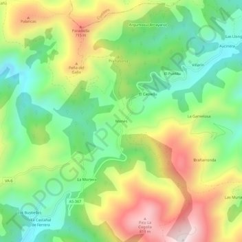
Name: Mones topographic map, elevation, terrain.

Location: Mones, Valdés, Asturias, Spain (43.48556 -6.36014 43.52556 -6.32014)

Average elevation: 473 m

Minimum elevation: 211 m

Maximum elevation: 855 m

Gear up for your next adventure:

🌬️Windproof Camp Stove - Efficient cooking even on exposed mountain peaks
🛶Kayak Dry Bag - Waterproof storage for kayaking adventures
🥾Waterproof Trail Shoes - Shoes designed to handle wet terrain
🥾Approach Shoes - Shoes designed for climbing approaches and rugged trails
🧦Outdoor Socks - Durable socks designed for hiking and outdoor sports

As an Amazon Associate, this site earns from qualifying purchases at no extra cost to you.