Geolocate

Liares topographic map

Click on the map to display elevation.

About this map

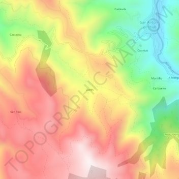
Name: Liares topographic map, elevation, terrain.

Location: Liares, Ibias, Asturias, Spain (43.00408 -6.91080 43.04408 -6.87080)

Average elevation: 713 m

Minimum elevation: 259 m

Maximum elevation: 1,093 m

Gear up for your next adventure:

👟Sport Hiking Sandals - Breathable footwear for water crossings and camp rest
Family Camping Tent - Spacious tent suitable for family camping trips
Tent Footprint - Protect tent floor and increase durability
🧴Waterproofing Spray - Restore the DWR coating on jackets and tents
🕯️Camping Lantern - Illuminates your entire campsite with high-efficiency LEDs

As an Amazon Associate, this site earns from qualifying purchases at no extra cost to you.