Geolocate

Boriñes topographic map

Click on the map to display elevation.

About this map

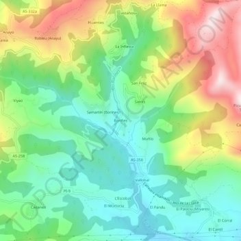
Name: Boriñes topographic map, elevation, terrain.

Location: Boriñes, Piloña, Asturias, 22534, Spain (43.37214 -5.33874 43.41214 -5.29874)

Average elevation: 310 m

Minimum elevation: 109 m

Maximum elevation: 659 m

Gear up for your next adventure:

💧Hydration Bladder - Hands-free hydration solution for long treks
🥾Hiking Leggings - Comfortable leggings for outdoor activities
🥾Trail Hiking Socks - Comfortable socks to prevent blisters and fatigue
🪑Insulated Seat Pad - Protect your seat from cold rocks and wet logs
🧣Evaporative Cooling Towel - Beat the heat during intense summer climbs

As an Amazon Associate, this site earns from qualifying purchases at no extra cost to you.