
Rockland County topographic map
Interactive map
Click on the map to display elevation.
About this map
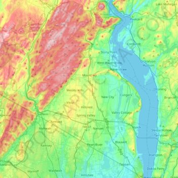
Name: Rockland County topographic map, elevation, terrain.
Location: Rockland County, New York, United States (40.99717 -74.23435 41.32493 -73.88665)
Average elevation: 138 m
Minimum elevation: 0 m
Maximum elevation: 424 m
Other topographic maps
Click on a map to view its topography, its elevation and its terrain.
Westchester County
Westchester County, New York, United States
Average elevation: 95 m
Hunter Mountain
United States > New York > Greene County
Hunter Mountain, Greene County, New York, 12450, United States
Average elevation: 1,004 m
City of Auburn
United States > New York > Cayuga County
City of Auburn, Cayuga County, New York, 13021, United States
Average elevation: 209 m
Stanley Manor
United States > New York > Onondaga County > Fairmount > Town of Camillus
Stanley Manor, Fairmount, Town of Camillus, Marcellus, Onondaga County, New York, 13108, United States
Average elevation: 189 m
Kings County
United States > New York > New York
Kings County, New York, United States
Average elevation: 9 m
Village of Saranac Lake
United States > New York > Franklin County > Town of Harrietstown
Village of Saranac Lake, Town of Harrietstown, Franklin County, New York, United States
Average elevation: 502 m
Town of Pharsalia
United States > New York > Chenango County
Town of Pharsalia, Chenango County, New York, 13758, United States
Average elevation: 502 m
Mountain Pond
United States > New York > Franklin County
Mountain Pond, Town of Franklin, Franklin County, New York, United States
Average elevation: 524 m
Salisbury Meadow
United States > New York > Rockland County > Town of Stony Point
Salisbury Meadow, Town of Stony Point, Rockland County, New York, United States
Average elevation: 97 m
Salisbury
United States > New York > Nassau County
Salisbury, Town of Hempstead, Nassau County, New York, United States
Average elevation: 34 m
City of Syracuse
United States > New York > Onondaga County
City of Syracuse, Onondaga County, New York, United States
Average elevation: 172 m
New York County
United States > New York > New York
New York County, New York, United States
Average elevation: 16 m
Town of Orchard Park
United States > New York > Erie County
Town of Orchard Park, Erie County, New York, 14127, United States
Average elevation: 272 m
Town of Hamilton
United States > New York > Madison County
Town of Hamilton, Madison County, New York, United States
Average elevation: 400 m
City of Watertown
United States > New York > Jefferson County
City of Watertown, Jefferson County, New York, 13601, United States
Average elevation: 150 m
Town of Riga
United States > New York > Monroe County
Town of Riga, Monroe County, New York, 14428, United States
Average elevation: 185 m
Village of Adams
United States > New York > Jefferson County > Town of Adams
Village of Adams, Town of Adams, Jefferson County, New York, United States
Average elevation: 189 m
Manhattan Island
United States > New York > New York
Manhattan Island, New York, United States
Average elevation: 17 m
Town of Smithtown
United States > New York > Suffolk County
Town of Smithtown, Suffolk County, New York, United States
Average elevation: 21 m
Roscoe
United States > New York > Sullivan County > Town of Rockland
Roscoe, Town of Rockland, Sullivan County, New York, United States
Average elevation: 487 m
Getzville
United States > New York > Erie County > Town of Amherst
Getzville, Town of Amherst, Erie County, New York, 14068, United States
Average elevation: 179 m
Lyon Mountain
United States > New York > Clinton County > Town of Saranac
Lyon Mountain, Town of Saranac, Clinton County, New York, United States
Average elevation: 951 m
Town of Mayfield
United States > New York > Fulton County
Town of Mayfield, Fulton County, New York, 12117, United States
Average elevation: 334 m
Town of Ava
United States > New York > Oneida County
Town of Ava, Oneida County, New York, United States
Average elevation: 420 m
Town of Irondequoit
United States > New York > Monroe County
Town of Irondequoit, Monroe County, New York, United States
Average elevation: 110 m
Town of Wilmington
United States > New York > Essex County
Town of Wilmington, Essex County, New York, 12997, United States
Average elevation: 517 m
Putnam Valley
United States > New York > Putnam Valley
Putnam Valley, Town of Putnam Valley, Putnam County, New York, 10537, United States
Average elevation: 130 m
Yorktown Heights
United States > New York > Westchester County > Town of Yorktown
Yorktown Heights, Town of Yorktown, Westchester County, New York, United States
Average elevation: 159 m
Village of Tuckahoe
United States > New York > Westchester County > Town of Eastchester
Village of Tuckahoe, Town of Eastchester, Westchester County, New York, United States
Average elevation: 57 m
Village of Hamilton
United States > New York > Madison County > Town of Hamilton
Village of Hamilton, Town of Hamilton, Madison County, New York, 13346, United States
Average elevation: 386 m
Village of Alexandria Bay
United States > New York > Jefferson County
Village of Alexandria Bay, Town of Alexandria, Jefferson County, New York, United States
Average elevation: 80 m
Town of Chazy
United States > New York > Clinton County
Town of Chazy, Clinton County, New York, United States
Average elevation: 57 m
Village of Arcade
United States > New York > Wyoming County
Village of Arcade, Town of Arcade, Wyoming County, New York, United States
Average elevation: 478 m
Town of Andes
United States > New York > Delaware County
Town of Andes, Delaware County, New York, 13731, United States
Average elevation: 615 m
Coopersville
United States > New York > Clinton County > Town of Champlain
Coopersville, Town of Champlain, Clinton County, New York, 12919, United States
Average elevation: 39 m
Lincoln
United States > New York > Wayne County
Lincoln, Town of Walworth, Wayne County, New York, United States
Average elevation: 153 m
Silver Bay
United States > New York > Warren County
Silver Bay, Town of Hague, Warren County, New York, 12874, United States
Average elevation: 218 m
Town of Guilderland
United States > New York > Albany County
Town of Guilderland, Albany County, New York, United States
Average elevation: 126 m
Village of Mamaroneck
United States > New York > Westchester County
Village of Mamaroneck, Town of Mamaroneck, Westchester County, New York, 10543, United States
Average elevation: 15 m
Town of Amherst
United States > New York > Erie County
Town of Amherst, Erie County, New York, United States
Average elevation: 184 m
Flanders
United States > New York > Suffolk County > Town of Southampton
Flanders, Town of Southampton, Suffolk County, New York, United States
Average elevation: 16 m
Onondaga Escarpment
United States > New York > Erie County > Village of Akron
Onondaga Escarpment, Village of Akron, Town of Newstead, Erie County, New York, 14001, United States
Average elevation: 235 m
Town of Bangor
United States > New York > Franklin County
Town of Bangor, Franklin County, New York, 12966, United States
Average elevation: 209 m
Waccabuc
United States > New York > Westchester County > Town of Lewisboro
Waccabuc, Town of Lewisboro, Westchester County, New York, 10597, United States
Average elevation: 183 m
Village of Silver Springs
United States > New York > Wyoming County > Town of Gainesville
Village of Silver Springs, Town of Gainesville, Wyoming County, New York, United States
Average elevation: 447 m
Mount Upton
United States > New York > Chenango County > Town of Guilford
Mount Upton, Town of Guilford, Chenango County, New York, 13809, United States
Average elevation: 387 m
Black Rock Mountain
United States > New York > Orange County > Town of Tuxedo
Black Rock Mountain, Town of Tuxedo, Orange County, New York, 10975, United States
Average elevation: 330 m
Heath Ridge
United States > New York > Westchester County > Village of Scarsdale
Heath Ridge, Village of Scarsdale, Westchester County, New York, 10583, United States
Average elevation: 66 m