
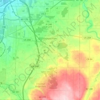
Town of Orchard Park topographic map
Interactive map
Click on the map to display elevation.
Town of Orchard Park topographic map, elevation, terrain
About this map
Name: Town of Orchard Park topographic map, elevation, terrain.
Average elevation: 272 m
Minimum elevation: 178 m
Maximum elevation: 424 m
Other topographic maps
Click on a map to view its topography, its elevation and its terrain.
Village of Lancaster
United States > New York > Erie County > Town of Lancaster
Average elevation: 209 m
Buffalo
United States > New York > Erie County
The Buffalo metropolitan area is on the Erie/Ontario Lake Plain of the Eastern Great Lakes Lowlands, a narrow plain extending east to Utica, New York. The city is generally flat, except for elevation changes in the University Heights and Fruit Belt neighborhoods. The Southtowns are hillier, leading to the…
Average elevation: 185 m
Onondaga Escarpment
United States > New York > Erie County > Village of Akron
Average elevation: 235 m