
Town of Irondequoit topographic map
Interactive map
Click on the map to display elevation.
About this map
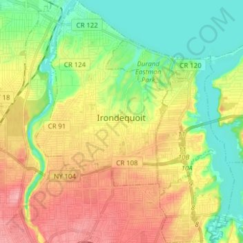
Name: Town of Irondequoit topographic map, elevation, terrain.
Location: Town of Irondequoit, Monroe County, New York, United States (43.16667 -77.62319 43.25704 -77.52184)
Average elevation: 110 m
Minimum elevation: 68 m
Maximum elevation: 163 m
Other topographic maps
Click on a map to view its topography, its elevation and its terrain.
Town of Penfield
United States > New York > Monroe County
Nearly two million years ago, Penfield's topography was formed by melting glaciers. The same forces that created the Finger Lakes helped develop interesting terrain in and around Ellison Park. These glacial ice melt carvings left fertile lands which today is used in farming (and from the late 20th century to…
Average elevation: 135 m