
Town of Ava topographic map
Interactive map
Click on the map to display elevation.
About this map
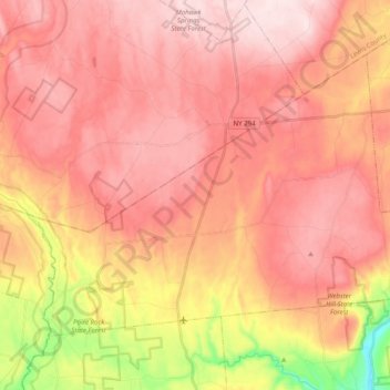
Name: Town of Ava topographic map, elevation, terrain.
Location: Town of Ava, Oneida County, New York, United States (43.38140 -75.56232 43.48566 -75.36355)
Average elevation: 420 m
Minimum elevation: 202 m
Maximum elevation: 532 m
Other topographic maps
Click on a map to view its topography, its elevation and its terrain.
City of Utica
United States > New York > Oneida County
City of Utica, Oneida County, New York, United States
Average elevation: 183 m
Stittville
United States > New York > Oneida County > Town of Marcy
Stittville, Town of Marcy, Oneida County, New York, 13469, United States
Average elevation: 173 m
Town of Verona
United States > New York > Oneida County
Town of Verona, Oneida County, New York, United States
Average elevation: 148 m
White Lake
United States > New York > Oneida County > Town of Forestport
White Lake, Town of Forestport, Oneida County, New York, 13494, United States
Average elevation: 453 m
Fish Creek
United States > New York > Oneida County
Fish Creek, Town of Annsville, Oneida County, New York, 13401, United States
Average elevation: 133 m