
Make a donation
Gear up for your next adventure:
As an Amazon Associate, this site earns from qualifying purchases at no extra cost to you.
Manhattan Island topographic map
Click on the map to display elevation.
Make a donation
Gear up for your next adventure:
As an Amazon Associate, this site earns from qualifying purchases at no extra cost to you.
Manhattan Island
Parkland covers a total of 2,659 acres (10.76 km2), accounting for 18.2% of the borough's land area; the 840-acre (3.4 km2) Central Park is the borough's largest park, comprising 31.6% of Manhattan's parkland. Designed by Frederick Law Olmsted and Calvert Vaux, the park is anchored by the 12-acre (4.9 ha) Great Lawn and offers extensive walking tracks, two ice-skating rinks, a wildlife sanctuary, and several lawns and sporting areas, as well as 21 playgrounds, and a 6-mile (9.7 km) road from which automobile traffic has been banned since 2018. While much of the park looks natural, it is almost entirely landscaped; the construction of Central Park in the 1850s was one of the era's most massive public works projects, with some 20,000 workers moving 5 million cubic yards (3.8 million cubic meters) of material to shape the topography and create the English-style pastoral landscape that Olmsted and Vaux sought.
Make a donation
Gear up for your next adventure:
As an Amazon Associate, this site earns from qualifying purchases at no extra cost to you.
About this map
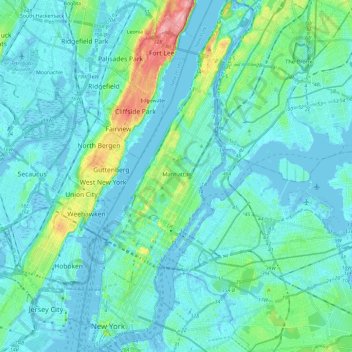
Name: Manhattan Island topographic map, elevation, terrain.
Location: Manhattan Island, New York, United States (40.69978 -74.01934 40.87762 -73.91044)
Average elevation: 17 m
Minimum elevation: -11 m
Maximum elevation: 117 m
Make a donation
Gear up for your next adventure:
As an Amazon Associate, this site earns from qualifying purchases at no extra cost to you.
Other topographic maps
Click on a map to view its topography, its elevation and its terrain.