
Make a donation
Gear up for your next adventure:
As an Amazon Associate, this site earns from qualifying purchases at no extra cost to you.
Greenville County topographic map
Click on the map to display elevation.
Make a donation
Gear up for your next adventure:
As an Amazon Associate, this site earns from qualifying purchases at no extra cost to you.
About this map
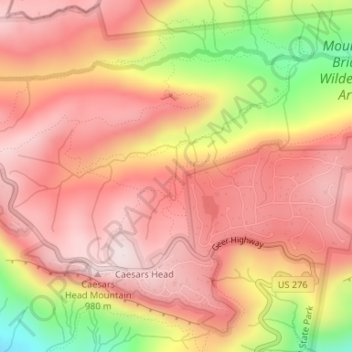
Name: Greenville County topographic map, elevation, terrain.
Average elevation: 819 m
Minimum elevation: 514 m
Maximum elevation: 975 m
Make a donation
Gear up for your next adventure:
As an Amazon Associate, this site earns from qualifying purchases at no extra cost to you.
Other topographic maps
Click on a map to view its topography, its elevation and its terrain.
Mount Pleasant
United States > South Carolina > Charleston County > Mount Pleasant
Average elevation: 3 m
Make a donation
Gear up for your next adventure:
As an Amazon Associate, this site earns from qualifying purchases at no extra cost to you.
Lake Secession
United States > South Carolina > Abbeville County
Secession Lake is a reservoir on the Rocky River, a tributary of the Savannah River. The spillway elevation is 548 feet (167 m) above sea level. The reservoir extends north into Anderson County, but the CDP consists only of residences built around the lake within Abbeville County. The Antreville CDP borders…
Average elevation: 188 m
Murphys Estates
United States > South Carolina > Edgefield County > Murphys Estates
Average elevation: 160 m
Make a donation
Gear up for your next adventure:
As an Amazon Associate, this site earns from qualifying purchases at no extra cost to you.
Make a donation
Gear up for your next adventure:
As an Amazon Associate, this site earns from qualifying purchases at no extra cost to you.
Make a donation
Gear up for your next adventure:
As an Amazon Associate, this site earns from qualifying purchases at no extra cost to you.
Make a donation
Gear up for your next adventure:
As an Amazon Associate, this site earns from qualifying purchases at no extra cost to you.
Ridgeland
United States > South Carolina > Jasper County
Ridgeland is in northeastern Jasper County, with the center of town sitting on a low ridge at an elevation of 62 feet (19 m) above sea level. According to the United States Census Bureau, the town has a total area of 44.7 square miles (115.8 km2), of which 44.4 square miles (115.1 km2) are land and 0.3 square…
Average elevation: 15 m
Make a donation
Gear up for your next adventure:
As an Amazon Associate, this site earns from qualifying purchases at no extra cost to you.
Make a donation
Gear up for your next adventure:
As an Amazon Associate, this site earns from qualifying purchases at no extra cost to you.
Make a donation
Gear up for your next adventure:
As an Amazon Associate, this site earns from qualifying purchases at no extra cost to you.
Skull Creek
United States > South Carolina > Beaufort County > Hilton Head Island
Average elevation: 3 m
Make a donation
Gear up for your next adventure:
As an Amazon Associate, this site earns from qualifying purchases at no extra cost to you.
Make a donation
Gear up for your next adventure:
As an Amazon Associate, this site earns from qualifying purchases at no extra cost to you.
Lexington County
United States > South Carolina
According to the U.S. Census Bureau, the county has a total area of 757.62 square miles (1,962.2 km2), of which 699.00 square miles (1,810.4 km2) is land and 58.62 square miles (151.8 km2) (7.74%) is water. The largest body of water is Lake Murray, while other waterways include the Broad River, the Saluda…
Average elevation: 116 m
Make a donation
Gear up for your next adventure:
As an Amazon Associate, this site earns from qualifying purchases at no extra cost to you.